Geology Reference
In-Depth Information
et al.
2011
,
2013
). It is important to note that almost no
socio-economic activities generating revenues for local
populations exists in the SSM village, whose name was
given to the
rst dam to be built in Moroccan territory in
1929 (
in the of
cial website of Ministry of Energy, Mines,
Water and Environment, Department of Water,
http://www.
water.gov.ma/index.cfm
) (Fig.
4
c). Several 1-day georoutes
could be developed within the basin.
3.1.3 Jbel Irhoud
Jbel Irhoud (Jbel means mountain in Arabic) represents a
faulted anticline of Early Cambrian karstic limestones and
shales. The succession in the general vicinity is 400
500 m
thick and, in addition to the deformed Palaeozoic rocks, also
preserves Triassic red beds and Quaternary calcareous
sandstones, in unconformable relationships to the older units.
This geosite is one of the most important fossil localities in
the Doukkala-Abda region (Fig.
6
). It is known for its
numerous hominid remains (see below), and also for its barite
mines. The Early Cambrian shales preserve A
rcheocyathus,
reef-building marine organisms of early Cambrian age that
lived in warm tropical and subtropical waters (Huvelin
1977
).
The Jebel Irhoud limestones contain many caves and
other examples of karst landforms. One of the caves, which
might have been used by Neanderthals, has yielded several
discoveries, the most important being that of the juvenile
Homo sapiens
, dated at 160,000 years. It is the oldest
member of modern
Homo
known with developed features in
Morocco (Hublin et al.
1987
; Hublin and Tillier
1988
;
Amani and Geraads
1993
,
1998
; Smith et al.
2007
). The
cave has also provided more than 425 pieces of worked
stone and tools of a Levallois-Mousterian technique. The
smoothness of some tool-tips suggests the high level of
intelligence of the Neanderthals (Hublin and Tillier
1988
).
In summary, the stratigraphical, palaeontological and
archaeological richness of Jbel Irhoud makes it one of the
most important geosites in the region. Its scienti
-
Fig. 3 a
The oldest volcanic rocks in Doukkala-Abda (Late Neopro-
terozoic rhyolites.
b
Simpli
ed lithostratigraphic section of El Jadida
headland with late Precambrian rhyolites in the core of the anticline
marine environments. The rocks have been tectonically
deformed and show structural features (various foliations,
folds, and faults), which are useful both for educational and
tourist purposes. The succession is made up of three main
formations: middle Cambrian rocks, predominantly shales
(Fig.
4
a), unconformably overlain by continental Triassic
rocks (Fig.
4
b) and marine Plio-Quaternary sedimentary
units (see Fig.
4
c, d, e and Gigout
1956
; El Attari
2001
;
Hminna
2005
, Hminna et al.
2013
). The volcanic complex of
the SSM consists of dolerite dykes and sills feeding basaltic
ows on the surface (Fig.
5
a, b). The emplacement of the
dolerites was synchronous with the sedimentation of the
Acadian (Middle Cambrian) Paradoxides shales. It repre-
sents a period of extensional intraplate alkaline magmatism
within Gondwana during the Cambrian (Ezzouhairi et al.
2004
). The Triassic formations correspond to a deposit
within a playa-like,
uvio-lacustrine system under semi-arid
conditions (Hminna et al.
2013
). The Triassic red-beds have
yielded the most
c, historical
and cultural values make it a site of heritage importance;
however, its location in a remote mining area increases its
vulnerability. Its preservation should be a matter of priority
for the local authorities.
interesting fossils, which include plant
prints, rhizoliths,
sh scales, and invertebrate and vertebrate
traces (Hminna et al.
2013
). Tetrapod footprints recorded in
this area are assigned to
Brachychirotherium parvum
, and
are considered the
rst record of Triassic tetrapod footprints
in Morocco outside of the High Atlas, and, indeed, the
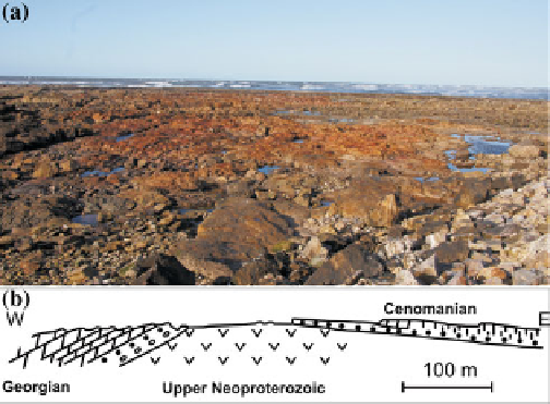
3.1.4 Lalla Fatna Escarpment
The Lalla Fatna geosite offers two contrasting coastal
attractions: one scienti
rst
record of the species in Africa (Hminna et al.
2013
). The
Late Triassic is marked by several
intercalated tholeiitic
c, the other touristic. The escarp-
ment, comprising a rock sequence of Mesozoic age, is sit-
uated at the top of a sandy beach, and is a rich source of
fossils (ammonites, brachiopods, bryozoa, cnidaria, echi-
noids). The beach itself offers considerable tourist potential.
The escarpment ranges between 115 and 150 m in height.
It consists mainly of three geological units forming part of an
anticlinal structure. (Fig.
7
a, b, Ettach
basalt
ows (Fig.
5
c), linked to central Atlantic rifting. These
ows crop out generally along the Oued Oum Er-Rbia. They
vary in thickness and color, the latter ranging from grey to
greenish, and they show varying stages of alteration
(Hminna
2005
).
With its scenic value, the SSM basin is a geosite of high
heritage interest that needs to be evaluated with the goal of
increasing the income of the local communities (Enniouar
ni et al.
1998
). The
units mark a transition from the Jurassic to the Cretaceous