Geology Reference
In-Depth Information
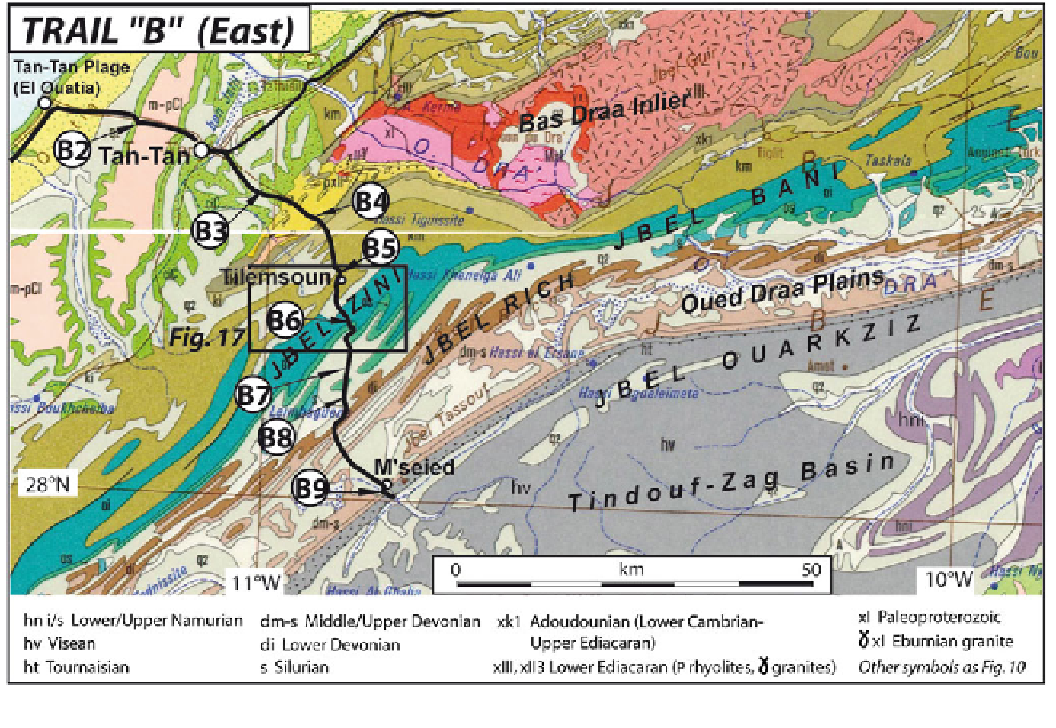
Fig. 15
Route and geosites location of the eastern part of geotrail
“
B
”
, plotted on the Geological map of Morocco (Hollard et al.
1985
)
Tarfaya Basin, the Precambrian crests of the Bas Draa
Massif and the Palaeozoic ridges
formations host the Azougar n
Tilili polymetallic and gold
mine prospect (El Hasnaoui et al.
2011
).
Geosite B5
is located ca 10 km farther in the south of
geosite B4 where the entrance to the Tilemsoun village is
marked by vertical, faulted quartzite beds (Fig.
16
c). These
massive quartzite beds belong to the upper part of the
Middle Cambrian
'
in the background
(Fig.
16
a).
Geosite B4
is situated within a short distance (1 km) of
geosite B3 in a shallow valley incised in the southwestern
Bas Draa Massif. The outcrops expose Upper Neoproterozoic
(Ediacaran, shown as
on the geological maps) vol-
cano-clastic conglomerates (Fig.
16
b), which, throughout
the Anti-Atlas, characterize the earliest post-Pan-African
orogenic formations deposited between 570 and 550 Ma
(Gasquet et al.
2008
). In these outcrops, the Ediacaran con-
glomerates are obviously affected by low-grade metamor-
phism and ductile deformation, which has resulted in two
superimposed foliations whose relative obliquity points to a
top-to-the-SE shear, consistent with the bulk orientation of
the folds around the massif. The Variscan deformation
affected the Precambrian basement itself, which illustrates the
“
“
PIII
”
“
Schistes
à
Paradoxides
”
(
“
km
”
in Fig.
15
,
“
”
“
km1a
in Fig.
17
); they are labelled
Barre quartzitique de
Goulimine
). Their geomorphologic role is very
important and compares with that of the Tabanit Sandstones
of the uppermost Middle Cambrian (
”
(
“
km1b
”
).
Once past the Cambrian quartzite landmark, the road to
Mseied crosses younger and younger clastic (Tabanit
Sandstones) and shaly (Fezouata shales) deposits up to a
pass across the Jbel Zini Quartzites of Lower Ordovician
age.
Geosite B6
offers outcrops along the road cuts, and a
panoramic view toward the south (Fig.
18
a) in the direction
of the end of the trail (Jbel Ouarkziz). A few ten metres after
the pass, the outcrops expose coarse, conglomeratic quartz-
ites, which belong to the Upper Ordovician. These pebbly
quartzites are equivalent to those described above at Awsard
(
geosite A9
), both being related to the Hirnantian glacial
event that affected the whole Saharan domain. In both cases,
“
km2
”
tectonic style of the Anti-Atlas (Burkhard
et al.
2006
). The low ridge bounding the valley to the
southeast corresponds to the Lower Cambrian clastics and
carbonates, which mark the very base of the marine Palaeo-
zoic series on top of the Bas Draa Precambrian basement. At
some distance (ca 25 km) in the east, these Lower Cambrian
thick-skinned
”