Geography Reference
In-Depth Information
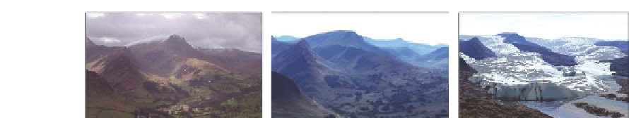
Figure 12.1
Landscape visualization in the Newlands Valley, Cumbria. Photographic representation
(left), computer-generated visualization from radar terrain model (centre); and a digital reconstruc-
tion of a retreating glacier in the valley around 15,000 years ago (right)
the southwest into the Newlands Valley, Cumbria. The reporting stage back in the field
centre involved groups developing a structured schema by which landscape visualizations
could be assessed against the real scenes, illustrating this with evidence gathered in the field
alongside the computer-generated imagery.
12.3 Outcomes from fieldwork exercises
The general approach has been found useful in engaging students in the nature of digital
surface modelling and raising awareness of visualization techniques. Having run similar
exercises for over eight years, it is possible to summarize some of the elements common to
the schemata developed by students in attempting to assess computer visualization against
reality. It should be remembered that the students were dealing with static views and that
landscape visualization can include a range of animated, interactive and immersive tech-
niques in addition to the photo-like snapshot. A conscious effort was made to maintain
focus on the static viewpoints in an attempt to manage the complexity of the problem
and separate representational fidelity issues from those concerning modes of interaction. It
should be acknowledged therefore that the following observations are not intended to be a
complete list, more an attempt to categorize some general issues which may be worthy of
further investigation.
Scale and complexity
- it is only when faced with real objects in the field that the implica-
tions of data scale or resolution become clear. The terrain model used here, for example,
wasa5mregular grid of elevation values, so features of width 5-10 m had little chance of
being represented and would at best be small undulations in the surface model. Objects of
this size were relatively unimportant when views contained predominantly distant terrain
characterized by broader topography of hills and valleys, where the scale of such features
became dominant over the resolution of the data.
Landscape composition and landmarks
- following on from the issue of scale, the relative
importance of key landmark features in the foreground or middle ground of a view can
be seen as affecting the type or composition of view. Clearly where foreground objects
are prominent, then the relative position of the observer to these is crucial and the view
changes markedly over a very small area. The nature of the landscape in Cumbria is such
that views are often dominated by, indeed generated by, hills or fells, which are often
referred to by name and used for orientation and navigation.


Search WWH ::

Custom Search