Geography Reference
In-Depth Information
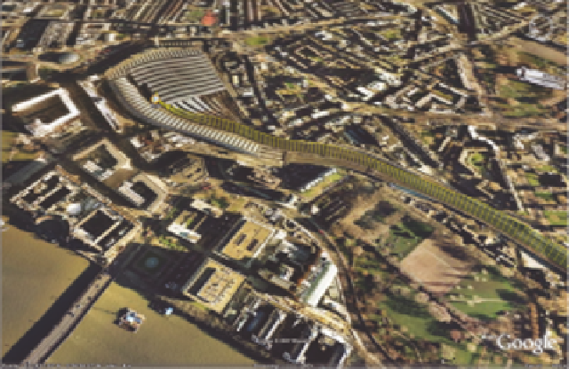
Figure 9.10
Personal GPS tracking data
The latest of these devices is the Nokia N95, a phone which features a 5 mega pixel
camera, wi-fi and more importantly a built-in GPS. As such it makes the perfect tool for
both capturing and communicating within the built environment-aportabletooltocreate
the Visual City. The camera has a high enough resolution for use in photomodelling and
SketchUp as well as holding up the possibilities of panoramic capture. The GPS unit allows
tracking of routes and the uploading of data to Google Earth.
Figure 9.10 Illustrates my route into Waterloo Station, London, tracked using the N95.
The height of the route represents speed, providing a unique insight into my own travel
into the city. The integration of GPS into devices such as mobile phones allows them to
be used outside of the traditional car-based environment and thus they become part of
our navigational abilities on foot. The ability to navigate through the physical city while
capturing digital data in real time or sending Tweets or geotagged photographs to Flickr
represents a key development in the Visual City. People generate data, data which up until
now has generally not been logged, let alone sent to a digital Earth for visualization.
In terms of the Visual City, it should not be assumed that there is one Visual City for
each urban area. Indeed we can identify numbers from one or two full three-dimensional
city models to hundreds of thousands for individual city visualizations. There is not as
such a single platform or database for the increasing amount of information that can be
captured. Google Earth provides a good basis with its Community Layer, which provides
information gathered by the public-at-large. The shear amount of information can, however,
be overwhelming and in general this layer is left switched off and therefore unseen by
the majority of users. The shear density of population in a city, and thus the amount of
information that could be input into system such as Google Earth, is resulting in vast
amounts of data of varying quality. While such data is of interest on a number of levels for
display, the move seems to be towards one of the personal yet shared Visual City rather than
a single collaborative database.


Search WWH ::

Custom Search