Geography Reference
In-Depth Information
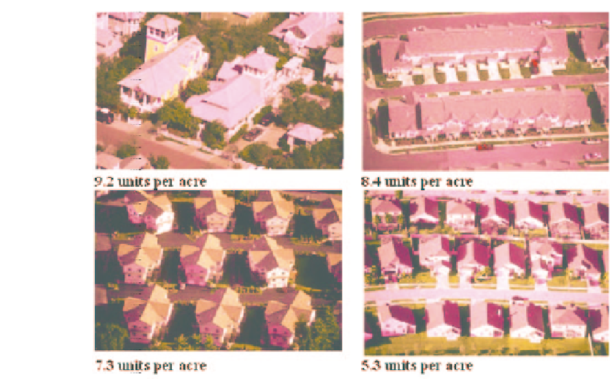
Figure 7.3
Examples of aerial photography in the 'Visualizing Density' catalogue. Densities shown:
9.2 units per acre (top left), 8.4 units per acre (top right), 7.3 units per acre (bottom left) and
5.3 units per acre (bottom right), October 2006 (source: author screenshot from www.lincolninst
.edu/subcenters/VD)
high-density developments and compact site plans (Hayden and MacLean, 2000). One of the
persistent obstacles to compact development is the public's aversion to density. Misplaced
concerns over density often prevent the construction of urban infill projects or the revision of
zoning regulations that would allow for compact growth. Campoli, Humstone and MacLean
(2003) argue that, while there is published work addressing the topic of density measures
that often state the desirability and benefits of density, they do not specifically address
the problem of measured vs perceived density. Low-altitude oblique aerial photographs,
however, are especially useful for the visualization of the character of urban areas and have
the potential to contrast images of differing residential densities (Figure 7.3).
In the
Visualizing Density
catalogue complied by Campoli and Maclean (2005), a collection
of over 300 aerial photographs illustrate more than 80 neighborhoods in locations across
the United States. The images are arranged by density level, measured as dwelling units
per acre. The catalogue is arranged on a continuum from low density (less than one unit
per acre) to high density (134 units per acre). It features a broad array of housing in many
different configurations, demonstrating that living closer together can take many forms.
By illustrating the physical form of density, Campoli and Maclean argue that the density
problem can be viewed as a design problem, shifting the publics' and planners' concerns
away from density numbers and toward appropriate design approaches. The purpose is to
increase the readers' familiarity with density numbers as they relate to neighborhood form,
and to enable viewers to visualize different design approaches to achieve density.


Search WWH ::

Custom Search