Geography Reference
In-Depth Information
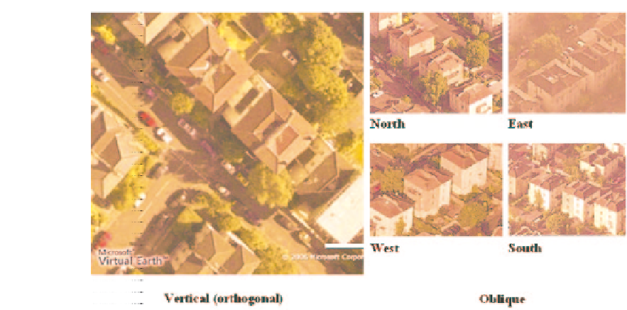
Figure 7.2
Vertical and oblique aerial photography available from MSN Virtual Earth, October 2006
(source: author screenshot from http://maps.live.com/)
may make some objects more recognizable. In this instance, the number of stories of the
building is revealed and this can be important in some planning situations such as when
calculating residential energy efficiency rates for individual dwellings. Also, oblique photos
may make some objects visible that are obscured from a vertical perspective, such as struc-
tures hidden by a protruding roofline. Low-level oblique aerial photographs can also show
the relative scale and sizes of buildings and the intricacies of urban areas and the landscape
'that the maps cannot convey, in which trees are more important features than building'
(St Joseph, 1977, p. 180). However, because scale varies across the image, oblique aerial
photographs cannot be used in photogrammetry.
7.2 Applications of aerial photography in planning-related
property research
7.2.1 Property attributes data extraction and collection
Detailed data on the housing stock is fundamental to many local planning authority func-
tions. However, attribute data for individual properties is difficult to collect and maintain
with many authorities relying upon secondary sources. These can include: sample surveys,
such as housing needs and house condition surveys; information from other sources, such as
local taxation registers and land registry records; information from property professionals
such as valuation officers, property surveyors and local real estate agents; or information
from comprehensive national surveys such as population censuses. There are several prob-
lems common with data from these sources: the data are collected infrequently and can
often be out of date; the data are based upon samples of houses rather than the total housing


Search WWH ::

Custom Search