Geography Reference
In-Depth Information
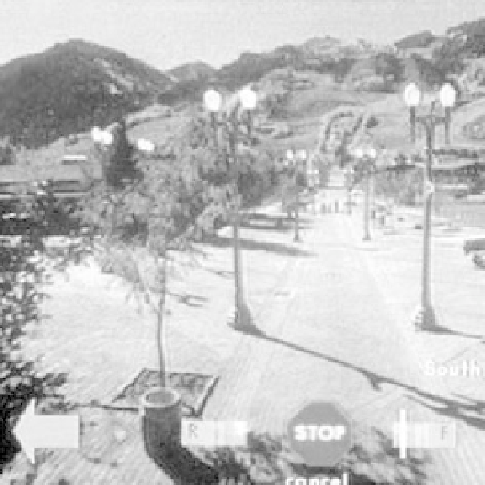
Figure 6.2
Screen shot from the Aspen Movie map (source: http:/www.rebeccaallen.com/v1/work/
list.php?isResearch=1)
(Wikipedia, 2006), used computer-controlled videodiscs to allow the user to 'drive' down
corridors or streets of Aspen, Colorado, USA. Every street and turn was filmed in both
directions. Users could enter buildings and view individual rooms. The interface is shown
in Figure 6.2.
6.2 Queenscliff Video Atlas
Following this inspiration, the author developed the
Queenscliff Video Atlas
(Cartwright,
1987) for videodisc. The
GeoExploratorium
contained information about buildings of ar-
chitectural significance in the historic township of Queenscliff, situated on the western
headland of the entrance to Port Phillip Bay, Victoria, Australia, providing a multimedia
historical and geographic information base.
A surrogate walk was included in the package. Maps, photographs, aerial photographs
and videotape were used to capture the streetscape of Queenscliff, plus views from the jetty
and of the Queenscliff coast. The contents of the videos include:
Queenscliff street blocks; and
views from the bay.
As opposed to still photography, block-by-block filming was thought necessary to give a more
informative view of the living conditions of the Queenscliff residents. The filming sessions
provided a collection of sequences containing individual street blocks in the Queenscliff
Township. Initially, all video footage was captured on BVU videotape. Filming of every


Search WWH ::

Custom Search