Geography Reference
In-Depth Information
medical problems, locating shopping centers, bringing
relief to refugees, and warning of natural hazards, to name
just a few.
Reference maps
show locations of places and
geographic features.
Thematic maps
tell stories, typically
showing the degree of some attribute or the movement of a
geographic phenomenon.
Reference maps focus on accuracy in showing the
absolute locations
of places, using a coordinate system that
allows for the precise plotting of where on Earth something
is. Imagine taking an orange, drawing a dot on it with a
marker, and then trying to describe the exact location of that
dot to someone who is holding another orange so she can
mark the same spot on her orange. If you draw and number
the same coordinate system on both oranges, the task of
drawing the absolute location on each orange is not only
doable but simple. The coordinate system most frequently
used on maps is based on latitude and longitude. For example,
the absolute location of Chicago is 41 degrees, 53 minutes
North Latitude and 87 degrees, 38 minutes West Longitude.
Using these coordinates, you can plot Chicago on any globe
or map that is marked with latitude and longitude lines.
The establishment of a satellite-based
global posi-
tioning system (GPS)
allows us to locate things on the sur-
face of Earth with extraordinary accuracy. Researchers col-
lect data quickly and easily in the fi eld, and low-priced units
are encouraging fi shers, hunters, and hikers to use GPS in
their activities. New cars are equipped with GPS units, and
dashboard map displays help commuters navigate traffi c and
travelers fi nd their way.
Geocaching
is an increasingly pop-
ular hobby based on the use of GPS. Geocachers use their
GPS units to play a treasure hunt game all over the world.
People leave the treasures (“caches”) somewhere, mark the
coordinates on their GPS, and post clues on the Internet. If
you fi nd the cache, you take the treasure and leave a new
one. Many mobile phones and “smart” devices are also
equipped with GPS units, and applications such as Google
Maps have helped to spread the use of GPS even further.
Relative location
describes the location of a place in
relation to other human and physical features. Descriptors
such as “Chicago is on Lake Michigan, south of
Milwaukee” or “Chicago is located where the cross-coun-
try railroads met in the 1800s” or “Chicago is the hub of
the corn and soybean markets in the Midwest” are all
descriptors of Chicago relative to other features. In the
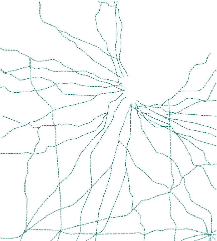
southern Wisconsin, northern Illinois, and western
Indiana region, all major roads lead to Chicago (Fig. 1.10).
Figure 1.10
All Major Roads Lead to Chicago.
Network of Midwestern roads that lead
to Chicago, refl ecting the dominance of
Chicago in the region.
© E. H. Fouberg, A. B.
Murphy, H. J. de Blij, and John Wiley & Sons, Inc.