Global Positioning System Reference
In-Depth Information
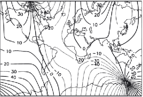
FIGURE 1.14.
Magnetic declination from true north in the year 2000.
Map from the U.S.
Geological Survey.
good, however, that they can predict ahead a few years. Thus, a magnetic
chart for 2012 can be predicted with reasonable accuracy from a map
obtained in 2010 from measured data.
Winds and Waves
Historically, much of navigation has been in the hands of mariners aboard
sailing ships. These ships are subject to the vicissitudes of wind and water;
it therefore behooves me to spend a small part of this chapter discussing
the patterns of winds and of surface ocean currents. These fluid move-
ments matter because they are long-lasting or seasonal, and predictable,
and thus can be a great help to mariners if not to navigators. A book twice
the size of this one might get to the heart of meteorology, but a single-
section summary can only scratch the surface. Some of the history of
navigation and exploration depends on established wind and ocean cur-
rents (for example, the discovery of Brazil by Europeans), and so you will
need to be aware of the existence of these phenomena, even if their cause
and interaction must remain mysterious.
The basic engine of planetary wind patterns is atmospheric heating.
This happens more at the equator than anywhere else. As a consequence,
equatorial regions tend to be low-pressure areas: heated air rises. This
rising air circulates poleward and cools, descending at the so-called
horse
latitudes
, which are 25\ to 30\ north and south. The cooling, falling air