Geography Reference
In-Depth Information
4.2. Technical grids
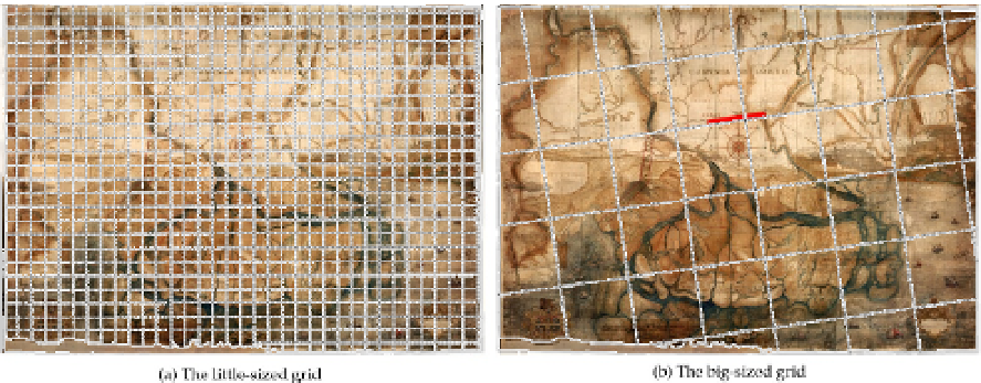
A small-sized square mesh grid, drawn in charcoal, is distinctly visible on all the three maps
(Figure 6a). The grids are characterized by different cell sizes: 10 cm on paper (about 1 km in
world) in F map, 7.7 cm (about 1 km) in P map, 4 cm (about 400 m) in L map. In the first
case, the cell size is exactly as long as half of the scale bar. This kind of grid covers the whole
map and is drawn parallel to the North branches of the compass-card and to the map edges.
Hence, the grid was probably helpful in assisting the transposition of the field-bearings onto
the map support. We cannot state if the numbering of the grid squares (characterising the P
map) had been used for this or other purposes, such as a mere scale reduction for copying.
Another very large sized grid exists on F map alone, and it is characterized by cells about
five times larger than those of the previous one (Figure 6b). The grid orientation does not fit
with the magnetic North, but coincides with a topographic direction clearly identifiable with
the most rectilinear street reach located along a wide artificial canal (
Rettinella
) between the
towns of
Loreo
and
Tornova
. It can be supposed that the canal was the starting baseline for
the survey of the central part of the mapped lands, according to the forward intersection
scheme showed by Fabri in his textbook (Figure 2c), assuming the still existing
Loreo
and
Tornova
bell towers as main reference points (Figure 2c, A and B points). Therefore, this
second grid could have probably been used by the map-maker to draw on the map the
azimuths measured in field and the sighting tracks toward all the noticeable points.
It is not possible to state whether the field survey strategy was the same for the other maps,
as in them a similar large grid does not exist. If it was, the same baseline would have
probably been used in P map (where it is clearly recognizable) but not in L map (where the
Rettinella
canal is roughly drafted in a marginal area of the map).
Figure 6.
Linedraw of the technical grids visible in F map, superimposed on the map. In (b) the
Rettinella
canal is highlighted in red.
4.3. Topographic measurements
Topographic measurements can be subdivided into three classes (Figure 7):