Geography Reference
In-Depth Information
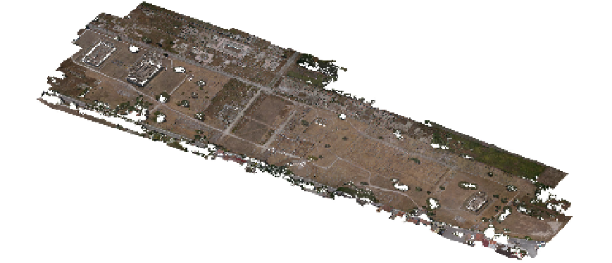
Figure 8.
3D Modell of Paestum, Italy (Task Group's Partner:
DAVAP Research Team
, University of
Valladolid, Spain).
There are also free multiplatform tools available to achieve these targets as 3D Studio Max,
Blender, Open FX and SketchUp, which provide powerful, integrated 3D modelling,
animation, rendering, and compositing tools. Some include full renderer and raytracing
engines, NURBS support, kinematics-based animation, morphing, and extensive plugin
APIs. Plugin capabilities include image post processor effects such as lens flare, and depth
of field.
For particular illumination effects, Lightsmark provides real time global illumination, colour
bleeding, and penumbra shadows.
Useful tools to study the territory and the landscape are GIS, that are used for geospatial
data management and analysis, image processing, graphics and maps production, spatial
modeling, and visualization. They allow to work with detailed maps in raster, vector, or
database format. Among them must be mentioned Quantum GIS, GRASS GIS, GDAL,
OpenEV, Thuban, and JUMP.
Virtual Terrain Project osters the creation of tools for easily constructing any part of the real
world in interactive, 3D digital form. For Digital Terrain Models (DTM) can be also used the
above mentioned Terragen free software.
Finally, SAGA (System for Automated Geoscientific Analyses) is an open source GIS
application with an emphasis on grid and raster functions: digital terrain analysis, geo-
statistics, and image processing.
3.3. Management and dissemination processes
Project management can be successfully developed with OpenProj, which is a desktop
project management application similar to Microsoft Project with a familiar user interface,
and even opens existing MS Project files. It is interoperable with Project, Gantt Charts, and
PERT charts. For Mac OS X.