Geography Reference
In-Depth Information
the Grândola, Sines and Santiago do Cacém municipalities, and the mountain Serra de
Grândola (maximum altitude: 383 m). Serra de Grândola extends up to the West coast, in a
regular and continuous form, without major abrupt changes in topography. Annual rainfall
ranges from 600 to 1,200 mm. The Atlantic-influenced climate is moderate, with average
annual temperatures of 17
0
C. Lithologically there are three important groups (1:50,000
Portuguese Geological Map; DGM, 1984): (i) in the highlands, the Flysch formation of the
lower Alentejo, (ii) in the highlands surrounding areas, sandstones and gravel of the littoral
of Lower Alentejo and Vale do Sado and, (iii) in the coastal zone, the beach and sand dunes.
Pedologically there is a predominance of Eutric Lithosols (highlands) and Podzols (coastal
zone).
3.3. Methodology
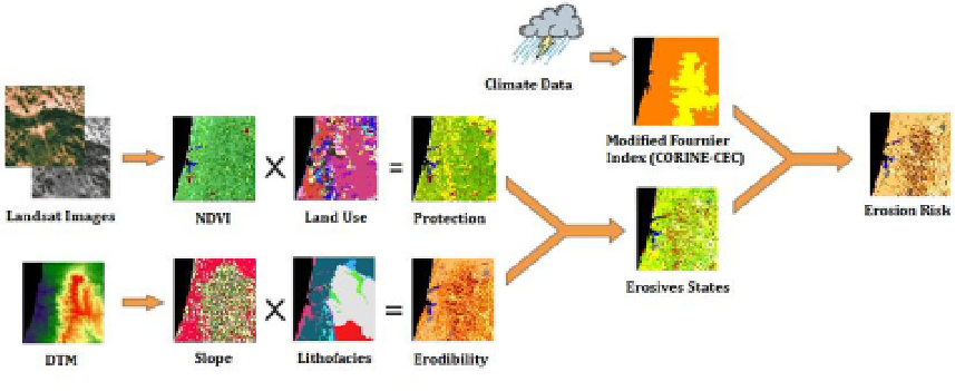
Based on the intersection of the soil's erosive status with the rainfall aggressivity, the latter
classified according to the Modified Fournier Index (MFI), the risk of erosion at the Serra de
Grândola was assessed (Figure 3) using IDRISI Taiga software (Eastman, 2009).
Figure 3.
Schematic of the methodology used in this application.
3.3.1. Mapping of the erosive status
The vegetation coverage map was obtained by applying vegetation indexes developed in
order to simplify the number of parameters present in the multi-spectral measurements.
These indexes, generated from remote sensing data, constitute an important way to include
anthropic activity in the ecosystems. Although there are many vegetation index available in
the literature, because vegetation has a high reflectance in Near Infra-Red (NIR) and a low
reflectance in R (
e.g.
, Lillesand
et al.
, 2004), this study used the Normalized Difference
Vegetation Index (NDVI), a technique introduced by Rouse
et al.
(1974) which enables to
know the density and the state (greenness) of the vegetation cover.
The land use information was obtained from the CORINE Land Cover map (CORINE-CLC,
2006) at a 1:100,000 scale. The map, based on satellite images SPOT-4, SPOT-5 and IRS-P6