Geography Reference
In-Depth Information
Figure 1.
Fixed Satellitary Monitoring System of the Territory and Civil Infrastructures achieved by
“SEPA Sistemi Elettronici Per Automazione S.p.A.” from Torino (Italy).
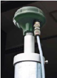
Figure 2.
GNSS receiver
The Field Sensor uses a single frequency GPS receiver to measure the carrier phase on the L1
GPS signal and an RF Modem for point-to-point communication with the base station via
radio link. A microcontroller supervises the communication and the exchange of data