Geoscience Reference
In-Depth Information
concentrated to this area where most of the torrential jhoras (Hill Streams) at their
upper catchments develop a potential sinking zone and the Hill Cart Road and
Narrow gauge Rail, when traverse through these zones, invite catastrophic slide.
The present work tried to identify the zones of potential slides by investigating into
the systematic interaction among the numbers of prominent triggering factors.
The Shivkhola watershed, a landslide prone spatial unit in Darjiling Himalaya,
dominated by a large number of destructive landslide events. Most of the landslides
took place at Tindharia, Lower Paglajhora, Gayabari, Shiviter and Nurbong. Since
the
first half of 20th century, the Watershed experienced following major landslip
events.
The landslip in Tindharia on 15th Januay, 1934 due to Bihar-Nepal earthquake.
Between the 11th and 13th June, 1950 a series of devastating landslide after a spell
of 834.10 mm rainfall around Kurseong, Darjiling Himalaya (Basu et al. 2003).
Landslide at Giddapahar near Kurseong damaged over 175 m of road and
railway track and demolished many bustee hamlets between 3rd and 5th
October, 1968 due to heavy rainfall of 1121.40 mm (Basu et al. 2003).
During 3rd and 4th September, 1980 again Tindharia was affected by severe
landslide due to heavy and concentrated rain of 299.1 mm (Basu et al. 2003).
During 15th and 16th September, 1991 numerous landslide phenomena at
Paglajhora and Chunabhati (Basu et al. 2003) due to 462.5 mm heavy rain.
During 11th and 13th July, 1993 innumerable landslide devastated Mahanadi,
Gayabari and Tindharia due to concentrated rainfall of 211.3 mm.
The year of 1995, 1998, 2001, 2002, 2003, 2006 and 2007 are major cases of
landslips along the Hill Cart Road mainly at Paglajhora, Giddapahar, Tindharia
and Gayabari.
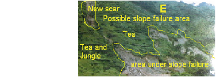
A devastating landslide at Shiviter Tea Estate in 2005 (Fig.
1.18
), which
destroyed a tea garden area of 1.5 acres (Field study by author, Tea Garden
Manager, 2006).
On 10th September, 2006 a devastating landslide took place along the Hill Cart
Road (Fig.
1.17
) at 14 miles Bustee and blocked the railway line for few days
due to sudden and catastrophic rainfall (Opinion Survey, 2007).
Fig. 1.18 Massive damage of
tea estate, Shiviter
Search WWH ::

Custom Search