Geoscience Reference
In-Depth Information
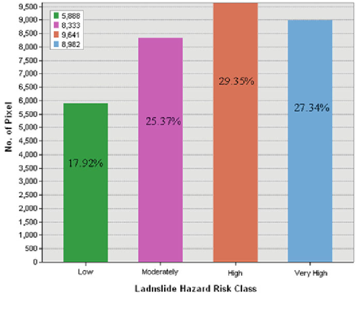
Fig. 7.10 Distribution of pixel/area (%) within landslide hazard risk classes
high intensity of risk elements (road, settlement and tea garden) that leads to high to
very high landside hazard risk. The developed landslide hazard risk map of the
Shivkhola Watershed exhibits a clear picture about the spatial location of vulner-
ability and risk of landslide hazard. The marginal parts and lower most segment of
the basin experiences low intensity of risk elements and are also least affected by
slope instability. Landslide hazard risk is very high at lower paglajhora, Shiviter
Tea Garden Area, Tindharia etc. Lower Gyabari and Sepoydhura are the places of
moderate to low probability of landslide hazard risk. Moderate level of risk is found
at middle as well as lower section of the Shivkhola Watershed. It can be concluded
that the watershed is dominated by the moderate to high level of landslide hazard
risk. Landslide hazard risk is too high at Mahanadi, Tindharia and Shiviter because
of higher intensity of the risk elements.
After thorough analysis of the intensity and magnitude of damage, 36 landslide
events are marked as risky out of a total of 128 since 1968. Again the distribution of
landslide among various landslide risk zone shows that very high, high and mod-
erate risk areas experienced 62, 43 and 22 landslide events respectively and out of
Search WWH ::

Custom Search