Geoscience Reference
In-Depth Information
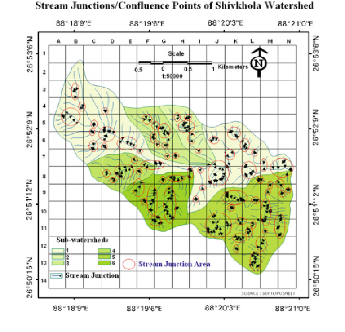
3.3.3 Drainage Concentration and Stream Con
fl
uence Point
The number of confluence points/junction points per unit area is an important index
in a river basin analysis. Confluence point is a place of union of two or more
streams over space which depends on the others geomorphic and geo-hydrologic
attributes of the basin. It is assumed that greater number of confluence points
indicate greater amount of erosion and drainage accumulation within the basin. The
sub-watershed 1, 2, 3, 4, 5 and 6 are experienced with 67, 15, 32, 14, 11 and 69
confluence points respectively. On the basis of these distributed confluence point in
each sub-watershed, it is inferred that the topography of sub-watershed 1 and 6 are
heavily dissected followed by sub-watershed 3, 2, 4 and 5. The southern part or the
right hand part of the main Shivkhola watershed (sub-watersheds-2, 3, and 6) is
attributed with large number of confluence points in comparison to northern part of
the basin (Fig.
3.5
) mainly due to topographic con
guration. The southern part is
registered with dominant erosion and changing slope surface by frequent and
gradual drainage convergence. It is also assumed from the drainage confluence map
Fig. 3.5 Stream junctions points of the Shivkhola watershed
Search WWH ::

Custom Search