Geology Reference
In-Depth Information
magnetism by the exposure of magnetic minerals to high temperatures. Elevated subsurface temperatures due to
combustion can alter the mineralogy of iron-bearing rocks and their magnetic properties, for example, remnant
magnetization and magnetic susceptibility.
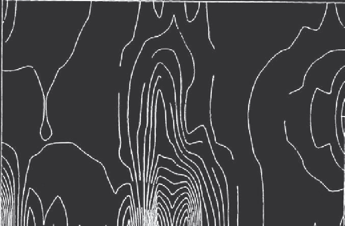
Three magnetic surveys were conducted over a 4-month period (Dalverny and Kim, 1995). For proton precession
magnetometer surveys, contour maps were constructed from field gradient and total field intensity values
determined at each grid point. The total field intensity at two depths and the magnetic field gradient calculated
from the field intensity were used to construct contour maps for each survey. The reinforcing metal in the old tipple
foundation created one magnetic anomaly (Figure 16.4.8.). Magnetic anomalies not associated with known metal
objects were identified in four areas within the grid (L1, 30, 35, 41m and L2, 30 m). Two of the magnetic
anomalies correlated to areas of subsurface heating.
Terrain Conductivity
In terrain conductivity, an electrical field is induced in the ground. The total electrical field that results from the
interaction of the induced field and materials in the ground is measured. With the instrument used in this test,
penetration depths were 3 and 6m (Dalverny and Kim, 1995).
The terrain conductivity data indicated anomalies at the approximate midpoint of the bank at the 3 and 6m depths.
The anomalies at 3 m were believed to coincide with heated areas. Those at 6 m depth were believed to indicate the
probable flow path of subsurface water.
Seismic Characterization
Seismic techniques were used to obtain subsurface data, such as waste thickness, waste heterogeneity, and nature of the
bedrock. Seismic refraction survey and tomographic imaging were the techniques used (Cohen and Dalverny, 1995).
A seismic refraction survey produced a two-velocity model for the area including the uppermost low velocity layer
of waste rock and the higher velocity bedrock layer. Velocities in the upper layer probably represented an average
or bulk velocity through varying percentages of waste rock, combustible material, and clay.
10
N
5
0
W60
50
40
30
20
10
0
E
East to west distance (m)
Figure 16.4.8. Results of magnetometer survey at Midvale Waste Bank: Contour plot of total field intensity
(gammas) indicates magnetic anomalies between 0 and 5 m north at the west end of the site from remains of
abandoned tipple. Other anomalies occur at 30m and at 40 m at the southern (0) end of the site. From Dalverny and
Kim 1995, p. 64.