Geology Reference
In-Depth Information
14.4. Coal-Fire Parameter
Extraction from Remote Sensing
Images
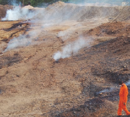
Photo illustrating an active, shallow sub-
surface coal fire with several active vents in
the Jharia coalfield, India. Remote sensing
technology for coal-fire parameter extrac-
tion is especially particularly suitable in
areas that are large, remote, inaccessible,
or hazardous.
Photo by Anupma Prakash, 2006.
Introduction
C
oal-fire areas are characterized by several typical surface features, also referred to as geoenvironmental
indicators of coal fires, that can be recognized, mapped, and quantified using remote sensing techniques. Some
other coal-fire parameters, such as fire depth, cannot be directly mapped but can be indirectly inferred. The
following is a brief discussion about the extraction of important coal-fire parameters that can be observed or
inferred from remote sensing images.
Crack-Density Mapping
L
ocal heating due to the presence of underground coal fires results in thermal cracking of the rock and soil layers
overlying the burn area. The dimensions and density of these cracks are variable; ranging from narrow, short,
and nearly vertical to massive cracks that are several meters wide and stretch for thousands of meters in length
(Figure 14.4.1). The intensity, depth, and longevity of burning in the subsurface will control the dimensions and
crack density (cracks per unit area) visible on the surface. In general, the intensity of the heat source and the crack
density are directly related, with the more intense burning causing greater thermal cracking. In addition, the more
shallow fires cause more surface cracking, whereas the deeper fires result in more massive cracks.
High spatial resolution remote sensing images are an excellent source for generating comprehensive maps of surface
cracks. Though traditionally these maps were created by manual tracing of cracks inferred from visual interpretation
(Chen, 1997), now crack-density mapping can be carried out using digital image processing techniques. In particular,
high pass digital filters can be applied to digital images to highlight linear and curvilinear features potentially
representing surface cracks. Crack densities can then be computed per unit area using geospatial statistical analyses
available with commercial software packages such as ArcGIS
. Although the digital technique is fast and efficient, it
has the potential of overestimating cracks as lineaments not associated with cracks may also be inferred as cracks by
the system.
™
Reflection-Aureole Mapping
A
s mentioned above, underground coal fires locally heat overlying rock and soil layers. The heating removes
moisture from the soil. The dryer soil and high temperatures are detrimental to the growth of vegetation, which first
becomes stressed and eventually dies. It is, therefore, common to see small halos of locally dry and highly
reflective barren areas in an otherwise relatively greener patch of land. These halos, called reflection aureoles or
barrenness aureoles (Gupta and Prakash, 1998), can be well detected on visible and infrared images as well as
TIR images (Figure 14.4.2).