Geology Reference
In-Depth Information
13.1. Airborne Thermal Infrared
Imaging
Daniel H. Vice
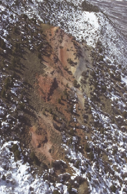
Airborne image of the Elk Creek Coal
Mine Fire, Garfield County, Colorado
(September 30, 2002). The view toward the
northwest (upper left) is along strike of the
Grand Hogback monocline. The red areas
are clinker, due to subsurface burning.
Photo courtesy of Steven Renner, Colorado Division of Reclamation, Mining and Safety.
Introduction
A
continuing problem in trying to control coal fires is determining their extent and direction of movement. The
extent of underground coal fires has been difficult to determine because of a number of surface factors, including
the amount of vegetative cover, the thickness of the rock and soil cover over the coal bed, and the varying intensity
of the coal fire over time can mask the location of the fire.
Thermal infrared (TIR) is a remote sensing method that detects variations of heat (i.e., radiant flux) on the Earth
s
surface. This method has been used to map and study fires associated with coal beds and/or coal mining culm banks
since the 1960s.
'
The purpose of this chapter is to review the use of airborne TIR for mapping and studying coal fires over the past
40 years. One reason for restricting the study to airborne TIR is that historically more use has been made of this
method due to its greater resolution and availability than of satellite TIR.
Thermal Infrared Imaging
T
hermal infrared imaging is a remote sensing method that detects differences in the radiant flux on the Earth
'
s
surface (Sabins, 1997). Since everything above absolute zero (
273°C) emits energy (i.e., radiant flux) in the
thermal infrared range of the electromagnetic spectrum (Gangopadhyay, 2007), the problem becomes how to
measure the differences. Variations in radiant flux from the ground surface are caused by differences in the ability
of rocks and other surface materials to absorb solar radiation and store this energy as heat (thermal capacity) and
then to emit this energy back into the atmosphere in the TIR range (Kahle, 1980; Sabins, 1997). Surface factors,
such as the amount of moisture in a soil, the presence of a stream or wetland, height differences of adjacent blocks
of trees in a forest, and/or active transpiration of trees in a forest, can affect the radiant flux and thus change the tone
of the TIR imagery. Topography can also create anomalies in TIR imagery, e.g., deep valleys may show as warm
areas because of transpiration of trees or being sheltered from the wind. Large animals, e.g., cattle or buffalo, can
also show up in the TIR imagery as hot spots and thus give false anomalies.
-