Geology Reference
In-Depth Information
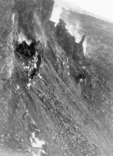
Figure 5.1.10. Coal seams burning in an opencast coal mine in the Beishan coalfield, Qitai County, China,
resulting in toppling failure, sliding, and collapse downslope. Reproduced with permission of Taylor & Francis.
From Bell and Donnelly 2006. Photo by Bell 1985.
have been associated with heat energy that had not dissipated from previous burning. The tip was reported
anecdotally to have undergoing combustion for at least the past 50 years.
The high temperatures recorded may have been influenced by the direction and intensity of prevailing winds
throughout the part of the year when the measurements were made. Stronger winds may allow more air to penetrate
within the spoil heap and so enhance combustion. Depending on the wind direction, odors from burning were
detectable on the western flank of the tip.
The dominance of red-shale on the southern part of the tip suggests that combustion may have been completed,
whereas burning does not appear to have occurred on the northern part of the tip. However, elevated ground
temperatures in the northern areas suggest that some degree of heat conduction and dispersion was occurring. Lime
dust was spread over parts of the tip and was successful in temporary reducing ground temperatures, although
combustion and elevated temperatures did eventually resume (Figure 5.1.13).
Infrared thermal imagery had been used to investigate the ground and in particularly shallow, abandoned
mine entries and mine workings in other locations with some success (Donnelly and McCann, 2000; Lamb,
2000). Infrared thermal scanning systems were therefore deployed at Shirebrook Tip to detect the direction
and rate of migration of the burning front. These techniques were shown to provide a cost-effective method
to rapidly assess the effect of burning on large areas of ground, which may otherwise have taken several
days or weeks, using conventional ground-based techniques. Pre-dawn airborne thermal data and daytime
multispectral thermal mapping are highly dependent upon a range of conditions such as local weather,
fluctuations in barometric pressure, time of day, and temperature inversions. However, pre-dawn thermal
imagery also provides qualitative data for mapping groundwater springs, entrapped moisture, and/or methane
seepages (Figure 5.1.14).
As part of the ground investigation, geophysical surveys were also undertaken and included magnetic, electro-
magnetic (EM), and resistivity surveys to delineate the areas of spontaneous combustion. The location of
geophysical anomalies provided the sites for the installation of temperature monitoring boreholes. The electrical