Information Technology Reference
In-Depth Information
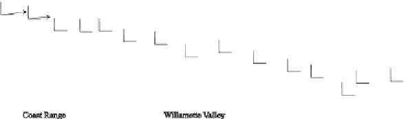
Fig. 12.58
Magnetic polar diagrams and real induction arrows along the continental part of the
Lincoln line: a - tipper polar diagrams at the period
T
= 2500 s, b - real induction arrows at the
period
T
= 6400 s
12.7.7 A New Geolectric Model of Cascadia: EMSLAB-III
The interpretation of data obtained on the Lincoln line is performed in the hypothe-
ses test mode by the method of partial inversions. It consists of three stages.
At the first stage, we carry out the one-dimensional inversion of short-period
curves of the effective apparent resistivity and impedance phase,
eff
, and
construct an approximate geoelectric section of the volcanic-sedimentary cover to
a depth of 3.5 km (Fig. 12.59). This section, consistent with the near-surface part of
the EMSLAB-I model (Wannamaker et al., 1989b), is incorporated into the starting
two-dimensional interpretation model.
At the second stage, we use the REBOCC program realizing the Occam razor
and conduct experiments with a smoothed two-dimensional inversion. Under the
complex conditions of the Cascadia subduction zone, the joint inversion of the TE
and TM-modes yields intricately alternating low- and high-resistivity spots with a
poor misfit minimization. The real structures of the subduction zone can hardly be
recognized in these queer spots. The most interesting result is obtained from the par-
tial inversions of the TE-mode (tippers and phases of the longitudinal impedance).
It is shown in Fig. 12.60. Here the vast western and eastern conductive zones are
distinctly outlined. They are separated by a rather narrow T-shaped high-resistivity
zone that relates to the downgoing oceanic plate. In this simple pattern, the western
and eastern conductors are identified as an oceanic asthenosphere with its top fixed
at a depth of about 30-40 km and as a crust-mantle area of dehydration and partial
melting in the depth range of 10-20 to 60-70 km. It is noteworthy that the upper
boundary of the eastern conductor resembles the relief of the crustal conductive
layer in the models EMSLAB-I and EMSLAB-II.
At the third, final, stage we apply the method of partial inversions and construct
a new geoelectric model of the Cascadia subduction zone called the EMSLAB-III
eff
and