Geoscience Reference
In-Depth Information
sediment cores that provide detailed records of sea surface
temperature (SST) and
δ
18
O of seawater (
δ
18
Osw) for most
of the last glacial cycle (approximately 48
-
8 ka).
2. PREVIOUS STUDIES OF DEGLACIAL MELTWATER
IN THE GULF OF MEXICO
first documented in the Gulf of
Mexico sediment cores based on
Deglacial meltwater was
18
O in planktic foraminif-
era and tied to LIS decay [Kennett and Shackleton, 1975;
Emiliani et al., 1975]. Planktic foraminiferal
δ
18
O reached
δ
minimum values of
in core K97 from the north
central Gulf of Mexico (Figures 2 and 3). Attempts to con-
strain the thickness of the inferred meltwater layer by com-
paring deeper-dwelling planktic foraminiferal
2.6
‰
18
O from
Neogloboquadrina dutertrei, which today lives throughout
0
18
O
record [Kennett and Shackleton, 1975] that first documented the
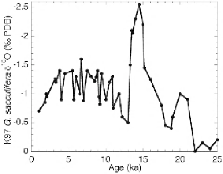
major deglacial meltwater spike centered at about 14.5 ka.
δ
Figure 3.
Sigsbee Plain core K97 Globigerinoides sacculifera
δ
uence in deeper
waters [Kennett and Shackleton, 1975; Leventer et al., 1983;
Flower and Kennett, 1990]. However, because planktic fo-
raminifera may change their depth preferences in order to
avoid low-salinity meltwater, the thickness is not well
constrained.
The geographic distribution of planktic foraminiferal
-
200 m [Bé, 1982], indicated minimal in
al., 1975], yet
1.2
‰
in a nearby core [Nürnberg et al.,
2008]. The relatively high
δ
18
O values in the latter core
(MD02-2575) led to the conclusion that meltwater did not
affect the eastern Gulf of Mexico [Nürnberg et al., 2008]. To
re-examine the geographic extent, we compile and plot sur-
face-dwelling planktic foraminiferal
δ
18
O
has allowed assessment of the areal extent of inferred melt-
water. An earlier compilation suggested decreased influence
with distance from the Mississippi Delta junction [Williams,
1984]. However, there is con
δ
18
Ominimaversus
linear distance from the Mississippi Delta junction (Figure
4 and Table 1). We restrict our comparison to records based
on the white variety of G. ruber. The data come from nine
locations, some of which have several cores (e.g., Orca Basin
has three cores). One location, LOUIS on the Louisiana
Slope, has multiple cores [Aharon, 2003], and we chose the
core with the best data resolution and age control.
icting evidence in the north-
eastern Gulf of Mexico near DeSoto Canyon. Deglacial
planktic foraminiferal
18
O reached minimum values of
δ
flank [Emiliani et al.,
1978],
2.2
‰
in one core from the eastern flank [Emiliani et
3.5
‰
in a core from the western
Figure 2.
Map showing core locations in the Gulf of Mexico. Core information is given in Table 1.


Search WWH ::

Custom Search