Geoscience Reference
In-Depth Information
portion of the Great Basin (Figure 1). I chose Coburn Lake
for the study because the lake is deep (13 m) relative to its
surface area (1.7 ha). This relationship suggested that Coburn
Lake might contain relatively undisturbed lake sediments
[Larsen et al., 1998]. Coburn Lake was also chosen for study
because it is located at the bottom of a small (44 ha), steep
watershed. This small watershed limits the spatial area from
which charcoal, that is deposited into Coburn Lake, can
come. The Coburn Lake watershed extends from 2280 to
2460 m (7480
Emergent and riparian vegetation are present today on Co-
burn Lake
'
s flatter and partially filled northern and eastern
margins. There is little emergent vegetation below steep
slopes on the lake
s southern and western margins. However,
relatively little of the lake
'
s watershed lies above the south-
ern and western margins of the lake.
'
3. METHODS
8060 ft) in elevation.
The Coburn Lake watershed currently experiences an up-
per montane Mediterranean climate with cold, snowy winters
and cool, dry summers. Located midway between the Paci
-
3.1. Methods in the Field
My colleagues and I collected two sets of cores from
approximately the center of Coburn Lake. These two sets of
cores were located >26 m apart to avoid resampling the same
location in the lake. Each set of cores included samples of the
water-sediment interface (top core sediments) and of deeper
sediments (deep core sediments). We used a gravity-activated
top corer to sample the water-sediment interface and a mod-
i
c
northwest and southwest regions, Coburn Lake does not
appear to share the typical El Ni
Southern Oscillation
(ENSO) response that either region experiences today.
Old-growth red r(Abies magnifica A. Murr.) currently
dominates vegetation within the heavily forested Coburn
Lake watershed. Subalpine mountain hemlock (Tsuga mer-
tensiana (Bong.) Carr.) codominates with red fir on cooler
and moister north facing slopes, while western white pine
(Pinus monticola Dougl. ex D. Don) codominates with red
ñ
o
-
ed 5 cm diameter, 1 m length Livingstone piston corer
[Wright, 1991] to collect a total length of 4.4 m of deep core
sediments.
While still in the
r
on warmer and drier south facing slopes and on dry ridge
tops.
Emergent and riparian vegetation sometimes serves to
filter out macrocharcoal that might otherwise reach the lake.
field, top core sediments were photo-
graphed and then subsampled at 1 cm intervals, unless smal-
ler intervals were required to determine the locations of
stratigraphic boundaries or charcoal visible in the core. Deep
core sediments were described in the field, wrapped in
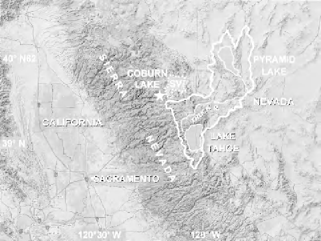
Figure 1.
Coburn Lake (
) is located north of Lake Tahoe, California, just below the east side of the Sierra Nevada crest
and adjacent to the Sierra Valley (SV) portion of the Great Basin Desert. The Truckee River (thin solid line) begins at the
northern end of Lake Tahoe, passes through Reno, Nevada, runs east and north from Reno, and ends at Pyramid Lake. The
watershed for Pyramid Lake is enclosed within a thick solid line.
θ


Search WWH ::

Custom Search