Geoscience Reference
In-Depth Information
the region. The pediplain is the second largest category that
occupies the central and southern areas. Denudational hills
occur near the towns of Jodhpur and Jaisalmer. Structural hills
occur near Siwana and Jodhpur. Alluvial plains occupy the
eastern part [Singhvi and Kar, 1992; Roy and Jakhar, 2002].
The region is almost sandy, dry and ill watered, forming the
arid and semiarid regions of India. However, in the neighbor-
hood of Jaisalmer, the terrain is stony containing numerous
rocky ridges. With these exceptions, the region looks like a
typical desert with numerous dunes, including the biggest
ones at Ramgarh and Sam near Jaisalmer. The landscape of
the region has evolved primarily through the aeolian process-
es [Roy and Jakhar, 2002; Valdiya, 2010]. Fluvial processes
and the paleodrainage system have contributed significantly
to the region. At the base of these hills, rocky/gravelly and
buried pediments are located, which are mainly concentrated
in the central, eastern, and northern parts of the region. Sand
dunes and interdunal plains are located in the northwestern
parts. Flat and sandy undulating plains of various length and
width are located in between these dunes.
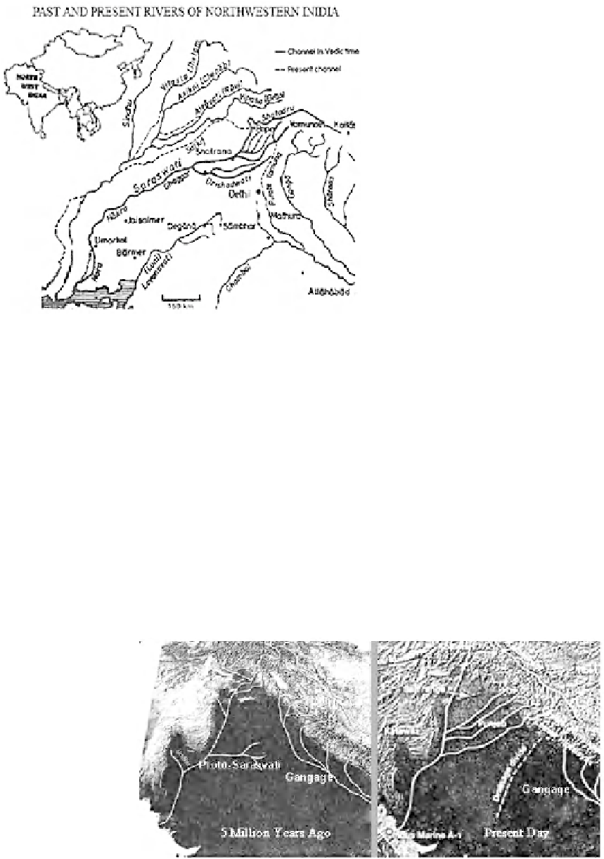
The Indus River and its tributaries (Jhelam, Chinab, Ravi,
Satluj, and Beas and ephemeral river Luni) are the only rivers
of this region that join the Arabian Sea (Figure 1). In addition
to the Ghaggar River, which ends in the sands of the Thar
Desert, paleochannels have also been identi
Figure 1.
Distribution of the past and present rivers in northwestern
India, 65.8°
-
80.2°E; 24.3°
-
36°N. From Oldham [1893].
2. PHYSIOGRAPHIC CONDITIONS
The region to the west of the Aravalli Mountain Range and
southwest of the Himalaya is occupied by a series of rock
formations ranging from the Precambrian to the Recent cov-
ered by a veneer of the fluvial and lacustrine sediments of the
Quaternary period and windblown sands of the great Thar
Desert.
Landforms in the area have been geomorphologically clas-
sified into three types based on their origin: aeolian (aeolian
plain), alluvial (alluvial plain and floodplain), and denuda-
tional (structural hills, denudational hills, piedmont zone, and
pediplain). The area of the aeolian plain covers a major part of
ed near Agolai
village and west of Jaisalmer constituting the remnants of the
lost Sarasvati River [Radhakrishna and Merh, 1999; Roy,
1999; Valdiya, 2002, 2010].
3. FOSSIL GROUNDWATER IN THE REGION
To meet the increased demand for water for drinking and
for agriculture in this water- scarce region where there is no
surface water source, both Indian central and Rajasthan
Figure 2.
Topographic map of the region, 64.2°
36°N, showing changes in drainage pattern during the last 5
million years. After Clift and Blusztajn [2005] and Paliwal [2008]. Reprinted by permission from Macmillan Publishers
Ltd: Nature, copyright 2005.
-
83°E; 23.8°
-


Search WWH ::

Custom Search