Geography Reference
In-Depth Information
continental growth by accretion as new mountain belts are formed progressively along the mar-
gins. (Adapted from Engel 1963: 145.)
The continents themselves are
isostatic:
They are composed of lighter rocks floating
on a substrate of denser rocks. This was confirmed by the seismologist
Mohorovicic,
who observed that earthquake waves travel at low velocity until reaching a certain
distance below the Earth's surface, where they speed up abruptly. He concluded this
was due to denser rocks in Earth's mantle, and that the increased velocity marked the
Earth's crustal base. The zone of density contrast between crust and mantle was subse-
quently named the
Mohorovicic discontinuity,
or simply the
Moho
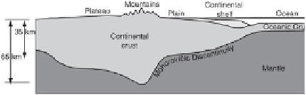
(Fig. 2.3). The crust
beneath the continents averages 20-30 km (12-19 mi) thick, but only 5-10 km (3-6 mi)
under the ocean basins. The deep roots under the major mountain ranges, where the
Earth's crust reaches its greatest thickness, descend to as much as 70 km (∼44 mi)
(Condie 2005).
FIGURE 2.3
Idealized representation of crustal thickness beneath continents and oceans. The
greatest thickness occurs under plateaus and mountains, the thinnest under the oceans. Contin-
ental shelves are largely underlain by geoclinal sediments and sedimentary rocks. (Adapted from
Holmes 1965.)
A fundamental question at this point is: What accounts for the great accumulations of
marine sediments that are present in the major mountain belts? Fossils collected near
the summit of Mount Everest at 8,850 m (29,035 ft), as well as many other high moun-
tain areas, indicate that these rocks were originally deposited in a shallow sea (Le Fort
1996). How is it possible for thick rock accumulations to have been continually depos-
ited in shallow water? The answer seems to be that these sediments were eroded from
the land and deposited in coastal areas, and as their weight increased, they gradually
depressed the underlying rock, allowing sedimentation to continue in shallow water.
Some deposits eventually reached thicknesses of up to 12,000 m (∼40,000 ft) in huge
linear, trough-like depressions. Such features, previously known as
geosynclines,
now
geoclines
or sedimentary basins, are known to be related to mountain building. Through
the study of ancient folded mountains such as the Appalachians, a typical geocline was
divided into two parallel components (King 1977): The inner continental part is com-
posed of gently folded limestones and quartz-rich sandstones, termed the
miogeocline;
the outer seaward part, the
eugeocline,
has many turbidites from undersea landslides
or turbidity currents. The eugeocline is more intensely faulted and folded, and perhaps
has abundant volcanic or intrusive igneous material (Fig. 2.4). European researchers
on alpine sedimentary basins in the Alps developed the term
flysch
for preorogenic
shale and rock fragment-rich, sandstone turbidites originally deposited in submarine
Search WWH ::

Custom Search