Geography Reference
In-Depth Information
more extreme environmental conditions (alpine) or resource competition (subalpine
forest) (van der Maarel 1990). The forest to alpine tundra ecotone is notable because
of its global occurrence and sensitivity to changes in regional and global climate, espe-
cially temperature changes. Lower forest boundaries are also good indicators of climat-
ic change in semi-arid mountain areas, where the lower treeline merges into grassland
or steppe vegetation because of a lack of moisture (Weltzin and McPherson 2000). In
both cases, the position and shape of local treeline can be highly variable, depending on
the role of several factors related to climate variability, topography, soil type, disturb-
ance, and the interaction among different species.
Biogeographers and ecologists have long been fascinated by the upper timberline,
and their research has introduced a wide range of terms (Nagy and Grabherr 2009).
Timberline
refers to the overall transition from closed forest to open treeless tundra.
Forestline
represents the upper limit of contiguous forest. Abrupt forestlines coincide
with timberline but may be indistinct where there is a gradual transition (
ecotone
) from
forest to tundra.
Treeline
is the upper limit of erect arborescent growth, represented by
scattered clumps of trees or isolated individuals above the forestline. Trees in this case
are usually defined as being 2-4 m (6-13 ft) high to differentiate between treeline and
the
scrubline
or
krummholz line,
the upper limit of stunted shrub-like trees (Arno and
Hammerly 1984). Krummholz is a German term meaning “crooked wood” and refers to
stunted, contorted trees living in extreme and usually windy environments. Little (1979)
further identifies a cushion krummholz zone located above the erect and often flagged
trees of the krummholz zone. These smaller cushion krummholz often extend well into
the alpine zone in areas protected by microtopographic ridges.
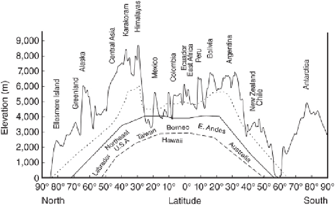
FIGURE 7.6
Global maximum elevation with modeled upper limit of the alpine zone (dotted line), ap-
proximate location of upper treeline (solid line), and the generalized temperature regimes sup-
porting forest vegetation (dashed line) (Modified from Körner 2007.)
Search WWH ::

Custom Search