Geography Reference
In-Depth Information
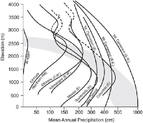
FIGURE 3.21
Generalized profiles of mean annual precipitation (cm) vs. elevation (m) in the tropics.
The shaded area shows the zone of maximum precipitation. (Adapted from Lauer 1975.)
The vertical distribution of precipitation illustrates yet another environmental dis-
tinction between tropical and extratropical mountains. The presence of a zone of max-
imum precipitation is well established for the tropics, but less defined in middle latit-
udes. Although there are insufficient measurements to settle the question categorically,
evidence from mass-balance studies on glaciers, runoff from mountain watersheds, and
improved methods of instrumentation seem to indicate that precipitation continues to
increase with altitude in middle latitudes, at least up to 3,000-3,500 m (10,000-11,000
ft). The decrease beyond moderate elevations in the tropics is explained by the dom-
inance there of convection rainfall, which means that the greatest precipitation occurs
near the base of the clouds. Where forced ascent is important, the level may be some-
what higher, but it does not vary more than a few hundred meters. In many tropical
areas, an upper air inversion composed of dry, stable air tends to restrict the deep devel-
opment of clouds. This is the case on Mount Kenya and Kilimanjaro, as well as on Mauna
Loa and Mauna Kea in Hawai'i (Juvik and Perreira 1974; Kaser et al. 2004; Hastenrath
2010).
RUNOFF
Mountain surface runoff is related to the topographic, biotic, pedologic, and, predomin-
antly, climatic characteristics of a watershed (Stewart 2009). In particular, seasonality
of precipitation inputs, temperatures, snowpack characteristics, and nonprecipitation
water sources (i.e., groundwater and glaciers) are important variables in determining
the amount of water flowing down a mountain stream (Peterson et al. 2000). Globally,
mountain runoff displays significant temporal and spatial variation. The temporal het-
erogeneity arises from the intraannual, interannual, and secular changes in temperat-
ure, precipitation, and other climatic factors (Xie et al. 2010; Clow 2010). Spatial het-
erogeneity is due to climatic, topographic, biotic, land-use, and pedologic variability
Search WWH ::

Custom Search