Geology Reference
In-Depth Information
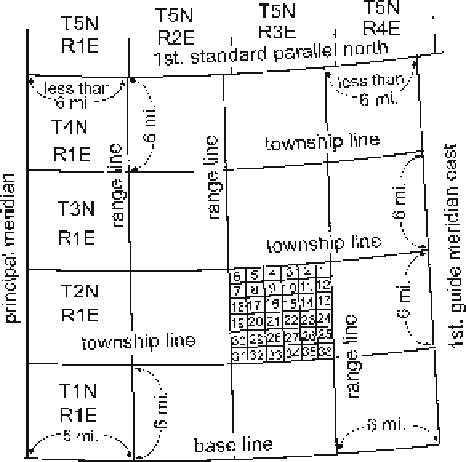
Fig. 2.2.
The Township-Range grid
system. The basic unit is a
24-mile block of 6-square-mile
townships. Township T2N,
R3E is divided into sections.
(After Greenhood 1964)
a quarter are given in feet measured from a point that is specified. The surveys were not
always done perfectly and were sometimes forced into irregular shapes by the topogra-
phy. It is necessary to see the local survey map to be certain of the locations.
Map scales are expressed as a ratio in which the first number is the length of one
unit on the map and the second number is the number of units of the same length on
the ground. The larger the scale of the map, the smaller the second number in the
ratio. Geological maps suitable for detailed interpretation are typically published at
scales ranging from 1 : 63 300 (1 in to the mile: 1 in = 63 300 in = 1 mile) to 1 : 24 000
(1 in = 24 000 inches, the 7.5 minute quadrangles of the USGS). Larger scales are useful
for making very detailed maps. Base maps should always contain bar scales which make
it easy to enlarge or reduce the map while preserving the correct scale.
Most governmentally produced base maps have an accuracy equivalent to the
U.S. Class 1 map standard (Fowler 1997). This standard states that the horizontal po-
sition of 90% of the points must be within 0.5 mm of their true location at the scale
of the map. For example, at the 1 : 24 000 scale, a point on the map must be within
0.5 mm
24 000 = 12 m (39.4 ft) of its true location. The vertical position of 90% of all
contours must be within half the contour interval in open areas and spot elevations
must be within one-quarter of a contour of their true elevation. A 20-ft contour (char-
acteristic of 1 : 24 000 USGS topographic maps) can be expected to be accurate to ±10 ft
(3 m). For comparison, the width of the thinnest contour line is about 0.01 in on a
1 : 24 000 USGS topographic map and represents 20 ft (6.01 m) at the scale of the map.
The accuracy of an enlarged (or reduced) map is no better than it was at the original
scale. Ground surveys of point locations such as wells can be expected to be accurate
to within 1 m and satellite surveys can be accurate to 0.1 m within the survey area
(Aitken 1994), significantly greater accuracies than that of many base maps.
×