Geology Reference
In-Depth Information
1.7
Sources of Structural Data and Related Uncertainties
The fundamental information generally available for the interpretation of the struc-
ture in an area is the attitude of planes and locations of the contacts between units.
The primary sources of this information are direct observations of exposures, well logs,
and seismic reflection profiles. These data are never complete and may not be correct
in terms of the exact locations or attitudes. Before constructing or interpreting a map,
it is worth considering the uncertainties inherent in the original data.
1.7.1
Direct Observations
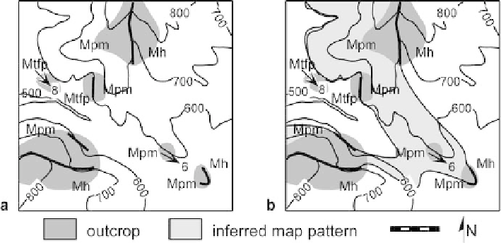
Outcrop- and mine-based maps are constructed from observations of the locations of
contacts and the attitudes of planes and lines. Good practice is to show on the working
map the areas of exposure at which the observations have been made (Fig. 1.43a). Expo-
sure is rarely complete and so uncertainties typically exist as to the exact locations of
contacts. Surface topography is usually directly related to the underlying geology and
should be used as a guide to contact locations. Contacts that control topography may be
traced with a reasonable degree of confidence, even in the absence of exposure, at least
where the structure is simple. The assignment of a particular exposure to a specific strati-
graphic unit may be in doubt if diagnostic features are absent. Bedding attitudes mea-
sured in small outcrops might come from minor folds, minor fault blocks, or cross beds
and not represent the attitude of the formation boundaries. The connectivity of the con-
tacts in the final map is usually an interpretation, not an observation (Fig. 1.43b).
Fig. 1.43.
Geologic map on a topographic base.
Contours
are in feet and the scale bar is 1 000 ft. Three
formations are present, from oldest to youngest:
Mtfp
,
Mpm
,
Mh
. Attitude of bedding is shown by an
arrow
pointing in the dip direction, with the dip amount indicated.
a
Outcrop map showing locations
of direct observations (
shaded
).
b
Completed geologic map, contacts
wide
where observed,
thin
where
inferred.
Lighter shading
is the interpreted outcrop area of the
Mpm