Geology Reference
In-Depth Information
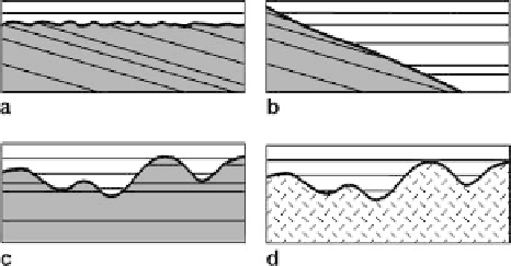
Fig. 1.8.
Unconformity types. The un-
conformity (
heavy line
) is the
contact between the older, un-
derlying
shaded
units and the
younger, overlying
unshaded
units.
a
Angular unconformity.
b
Buttress or onlap unconfor-
mity.
c
Disconformity.
d
Non-
conformity. The patterned unit
may be plutonic or metamor-
phic rock
1.3.2
Unconformities
An unconformity is a surface of erosion or nondeposition that separates younger strata
from older strata. An angular unconformity (Fig. 1.8a) is an unconformity between
two groups of rocks whose bedding planes are not parallel. An angular unconformity
with a low angle of discordance is likely to appear conformable at a local scale. Distin-
guishing between conformable contacts and low-angle unconformities is difficult but
can be extremely important to the correct interpretation of a map. A progressive or but-
tress unconformity (Fig. 1.8b; Bates and Jackson 1987) is a surface on which onlapping
strata abut against a steep topographic scarp of regional extent. A disconformity (Fig. 1.8c)
is an unconformity in which the bedding planes above and below the break are essen-
tially parallel, indicating a significant interruption in the orderly sequence of sedi-
mentary rocks, generally by an interval of erosion (or sometimes of nondeposition),
and usually marked by a visible and irregular or uneven erosion surface of appreciable
relief. A nonconformity (Fig. 1.8d) is an unconformity developed between sedimen-
tary rocks and older plutonic or massive metamorphic rocks that had been exposed to
erosion before being covered by the overlying sediment.
1.3.3
Time-Equivalent Boundaries
The best map-unit boundaries for regional structural and stratigraphic interpretation
are time-equivalent across the map area. Time-equivalent boundaries are normally
established using fossils or radiometric age dates and may cross lithologic boundaries.
Volcanic ash fall deposits, which become bentonites after diagenesis, are excellent time
markers. Because an ash fall drapes the topography and is relatively independent of
the depositional environment, it can be used for regional correlation and to determine
the depositional topography (Asquith 1970). It can be difficult to establish time-equiva-
lent map horizons because of the absence or inadequate resolution of the paleonto-
logic or radiometric data, lithologic and paleontologic heterogeneity in the deposi-
tional environment, and because of the occurrence of time-equivalent nondeposition
or erosion in adjacent areas. Time-equivalent map-unit boundaries may be based on
certain aspects of the physical stratigraphy. A
sequence
is a conformable succession of