Geology Reference
In-Depth Information
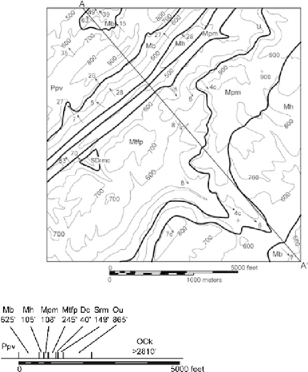
Fig. 6.17.
Geologic map of a portion
of the Sequatchie anticline
at Blount Springs, Alabama,
showing the line of cross sec-
tion. Geologic contacts:
wide
lines
, topographic contours
(ft):
thin lines
, measured bed-
ding attitudes are shown by
arrows
.
c:
Attitude computed
from three points
Fig. 6.18.
Stratigraphic column for the Sequatchie anticline map area at the same scale as the map,
to be used as a stratigraphic ruler. Thicknesses are in feet. Thicknesses of Ppv through Mpm are
from outcrop measurements. The top of the Ppv is not present in the map area. Thicknesses of Mtfp
through OCk are from the Shell Drennen 1 well (Alabama permit No. 688) interpreted by McGlamery
(1956), and corrected for a 4° dip. The well bottomed in the OCk and so the drilled thickness is less
than the total for this unit
The first step is to transfer the data from the map to the cross section. The line of
section is drawn on the map (Fig. 6.17), at right angles to the fold axis. The topography
is drawn using the method of Fig. 6.12, with the vertical scale equal to the map scale
(Fig. 6.19). The geologic contacts are shown by arrows and the dips close to the line of
section are shown as short line segments. The stratigraphic ruler is shown intersecting
the topography at the projected surface location of the well that provided the thick-
nesses of the subsurface units. The geological data in solid lines on Fig. 6.19 form the
data section which should not be subject to significant revision.