Geoscience Reference
In-Depth Information
2000; Naiman
et al.
, 2005; Lindenmayer and
Hobbs, 2007; Darby and Sear, 2008). In this way,
the core requirements of European landscape
and wildlife legislation and agreements can be
addressed (Council of the European Communities,
1992; Aalborg Charter, 1994; Council of Europe,
Committee of Ministers, 2008). An illustration of
this is the use of an integrated evaluation model to
produce an Environmental Landscape Plan for the
River Adige in northern Italy.
The Integrated Evaluation
Model
An Integrated Evaluation Model (IEM) (Braioni
et al
., 2009) has been developed using five key
steps:
1.
Careful planning of data collection from a
variety of sources, to determine the type of
information needed for meaningful comparison
between different scientific and other disciplines.
2.
Collecting the necessary data in a way that
allows comparison of aggregated and disaggregated
information
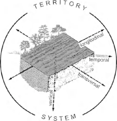
Figure 28.1
A five-dimensional approach for
considering river conservation (modified from Ward,
1989 and Boon, 1992).
economic assets to achieve sustainable river
management based on ecosystem functioning
(Sukhdev
et al
., 2010; Everard, this volume).
Considerable effort has been invested in multi-
disciplinary river research since the 1980s (Naiman
and D ecamps, 1990). As a consequence, the
conceptual dimension in a five-dimensional
approach for considering river conservation
(Boon, 1992) has expanded the previous four-
dimensional river ecosystem concept (Ward,
1989) and encouraged the integration of different
scientific disciplines. The idea of 'territory' in
Boon's conceptual dimension corresponds well
with Italian law and planning (Figure 28.1) and
provides the basis for the development of models
and indices suitable to analyse and integrate the
results into multi-disciplinary evaluations (Braioni
et al
., 2002, 2008a, b, 2009). These can be used in
conjunction with ecological, landscape and other
methods of analysis developed since the 1990s to
support the conservation and restoration of rivers
(Calow and Petts, 1994; Harper and Ferguson,
1995; Federal Interagency Stream Restoration
Working Group (FISRWG), 1998; Majone
et al
.,
for
different
specific
purposes
of
research and dissemination.
3.
Data management, using complementary tools,
methods and indices designed to provide a
diagnostic ability to distinguish the individual
components of the river channel, riparian areas and
river corridor as well as combining them to answer
specific aims of the study. This approach allows
different scenarios to be determined by altering one
or more variables such as: (i) natural, artificial and
historical elements of the landscape; (ii) specific
wildlife habitats; and (iii) those components of the
river and floodplain ecosystems which contribute
to self-purifying processes.
4.
Integration of the results in a practical plan or
project, based on the management of the river
channel and corridor using an evaluation system of
quality/degradation/risk to produce an ecological-
environmental landscape map identifying potential
land uses (Braioni
et al
., 2006, 2008b).
5.
Producing
guidance
material
based
on
a
combination
of
checklists,
scenarios,
standards,