Geoscience Reference
In-Depth Information
At the same time, Deer Creek is a critical
habitat for the remnants of spring-run chinook
salmon (
Oncorhynchus tshawytscha
), a species listed
as threatened under the US Endangered Species
Act. As the Sacramento River and its major
tributaries were dammed in the 20th century, Deer
Creek (along with other small tributaries, Mill and
Butte Creeks) assumed greater importance as a fish
habitat. The salmon traverse the lower, alluvial
reach en route to remote canyons cut into volcanic
rocks that offer them suitable spawning and rearing
habitat. Autumn-run chinook use the alluvial
reach for spawning, and spring-run, winter-run,
and other salmonids, mostly from other drainages,
use the alluvial reach for (non-natal) rearing.
However, habitat quality is limited by lack of
riparian vegetation and shade, the channel form
is very simple, and the gravel sizes (D
50
from
55-190 mm) are larger than ideal for chinook
salmon spawning (Kondolf and Wolman, 1993).
The channel lacks complex features that provide
good habitat, such as tight bends and secondary
circulations, undercut banks, scour pools, woody
debris jams, and a well-developed pool-riffle
sequence. In response to these problems, salmon
restoration programmes in the 1990s proposed
planting vegetation along the low-flow channel
banks and mechanically constructing spawning
riffles by adding smaller-sized gravels to the creek
(CDFG, 1993; USFWS, 1995; CALFED, 1997).
However, a geomorphic analysis concluded that
the underlying cause of the habitat degradation
was the flood control project (DCWC, 1998).
Aerial photographs from 1938 showed that before
the flood control project the channel was highly
complex, with frequent pool-riffle alternations,
meander bends, and gravel bars, with trees
overhanging the channel, undercut banks and
log jams (Figure 18.10a). Aerial photographs
taken after the flood control project showed a
marked simplification of the channel and thus
loss of habitat (Figure 18.10b). Moreover, channel
maintenance requires clearing accumulated gravel
bars, and levees constrain high flows within
the low-flow channel (concentrating flow and
increasing shear stress on the channel bed more
than when floods overflowed from the channel)
(a)
(b)
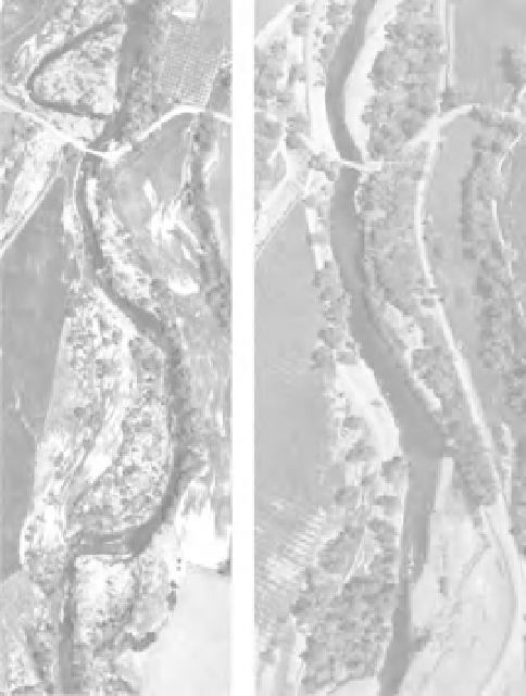
Figure 18.10
Details from aerial photographs of alluvial
Lower Deer Creek (a) in 1938, and (b) 1997, showing
the transformation of Deer Creek from a multi-threaded,
complex channel to a simplified, wider main channel
with higher shear stress in floods. Also visible in the
1997 photo detail is the levee breach along the left
(south) bank. Flow is from top to bottom, length of river
shown is about 1100 m.
(DCWC, 1998). Thus, if, as had been recommended
by the salmon restoration programme, riparian
vegetation were to be planted and spawning riffles
constructed, they would probably wash out in
the high shear stresses of the constrained levee
system. With the process altered by the levees, such
constructed forms would be unlikely to persist.
Thus, the habitat problems previously identified
along Deer Creek (lack of shading, simplified
channel form and too-coarse spawning gravels)
were all symptoms of an underlying cause:
the effects of a flood control project built five
decades before. Rather than spend restoration
funds on treating the symptoms (planting trees