Geoscience Reference
In-Depth Information
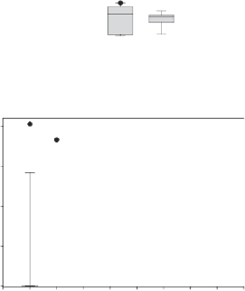
20
River type 3
15
10
outliers
P90
P75
5
median
mean
0
P25
0.5
1
1.5
2
2.5
P10
River Stretch Length (km)
outliers
20
River type 4
15
10
Figure 16.4
Box plot showing the
relative area of alder-ash alluvial forest
along river types 3 and 4 in Cantabria,
showing the mean, median and percentile
values. Figures calculated as river reaches
in reference condition in cumulatively
increasing 500 m lengths (0.5-4 km).
5
0
0.5
1
1.5
2
2.5
3
3.5
4
River Stretch Length (km)
Combining the three specific indicators provided
a final score for the conservation status for each
habitat. Favourable status was only achieved if all
three indicators were favourable and the habitat
was not considered vulnerable (Figure 16.5).
reaches (average survey length, 66.0 m) during
August-September 2010, using either portable
(2 kW) or on-site (13 kW) electro-fishing units.
Population
was
estimated
from
multiple
pass
removal methods (Carle and Strub, 1978).
The proportion of the near-natural ('reference')
habitat currently occupied by salmon was used as
a principal indicator, with favourable conservation
status achieved only where the occupied
distribution was at least 60% of the expected
distribution range. This criterion was selected
in accordance with IUCN guidelines which state
that a species is vulnerable or endangered when
50% of its range is lost, and at risk of extinction
when more than 70% of its range is lost over a
three-generation time period (IUCN, 2001). Three
Conservation status assessment for
Atlantic salmon
Conservation status was assessed using a
combination of angling catch records (1990-2008)
and
spawning
gravel
and
electro-fishing
surveys
(Figure
16.1).
Salmonid
spawning
gravels
were
mapped
in
all
main
rivers
during
September-December
2007
and
2008.
Fish
populations
were
surveyed
in
96
river