Geoscience Reference
In-Depth Information
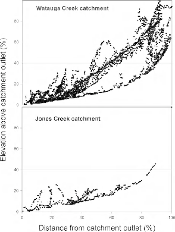
Figure 8.8
Elevation above and
distance from the catchment outlet of
developed areas in the Watauga and
Jones Creek catchments. The axes are
expressed as percentage of the total
elevation or distance from the
catchment. Lines are drawn at 40%
elevation - developed areas above this
line are considered mountainside
development.
Discussion
near-stream corridor land-cover in predicting
stream water chemistry (reviewed by Allan, 2004).
The results have been highly variable, depending
on the dominant land use, catchment topography,
and the specific chemical variables considered.
Most studies have shown that whole catchment
land-cover is most useful for nitrate, other mobile
chemicals, and specific conductance (Omernik
et al
., 1981; Hunsaker and Levine, 1995; Jones
et al
., 2001; Sliva and Williams, 2001; Sponseller
et al
., 2001; Strayer
et al
., 2003). On the other
hand, riparian land-cover is a better predictor
of forms of phosphorus, total suspended solids,
and
Exurbanization is changing both the land cover and
land use within the Upper Little Tennessee River
Basin. The results of this study clearly indicate the
value of distinguishing between land cover and
land use (Figures 8.2, 8.3) in evaluating effects on
stream water quality. While some variables were
better predicted by land cover (specific conductance
and nitrate), other variables were more related to
land use in the exurbanizing landscape of the Upper
Little Tennessee River Basin.
Many
studies
have
compared
the
usefulness
other
sediment-related
variables
(Osborne
of
whole
catchment
land-cover
to
riparian,