Graphics Programs Reference
In-Depth Information
What is Survey Data?
Think back to the last time you played connect-the-dots to draw a picture.
Ever wonder who made the dots and how they were made? I'm no expert, but
I'm guessing someone took the original picture, laid a piece of tracing paper
over it, and made dots along the edges of key features in the picture. Someone
skilled at this would make just enough dots to define the features but not so
many as to make them confusing or wasteful. The dots are a way of capturing
an image and transferring it to another location.
In land development, the land is the picture and the surveyor is the one who
makes the dots—referred to as
points
. Obviously, tracing paper can't be used, so
the surveyor lays an imaginary grid over the land (a coordinate system) and cre-
ates the points as information by recording their coordinates on this grid paper.
The tools the surveyor uses are extremely accurate and are capable of captur-
ing the location of each point within a tolerance of about
1
⁄
8
of an inch (3 mm).
Something different about the surveyor's “dots” is that their location is recorded
in all three dimensions. This enables a technician to play connect-the-dots in 3D
to create a 3D model in addition to a 2D map of the features of the land. Another
difference is that a surveyor's dots have description codes next to them instead
of just numbers. A
description code
identifies the type of feature that a dot, or
point, is intended to represent (see Figure 3.1).
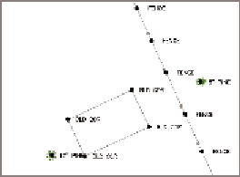
FiGuRE 3.1
Survey points shown as dots, giving
a sense of how they are used to create mapping
If you're thinking that it takes a lot of points to capture several acres of land,
you're absolutely right. How can you keep track of all those points? How can
they be easily turned into a 3D model of the land? Is there some way of automat-
ing the connect-the-dots process? Civil 3D has the answers to these questions,
and in this chapter, you'll learn how you can use Civil 3D to transform raw field
points into maps and 3D models of the land.