Graphics Programs Reference
In-Depth Information
Exercise 18.4: Analyze using a Quick Profile
In this exercise, you'll use quick profiles to study the interaction between
existing ground and proposed ground in the pond area and in the area
between the interior lots.
◀
If you haven't already
done so, download
and install the files for
Chapter 18 according to
the instructions in the
Introduction.
1.
Open the drawing named
Using a Quick Profile.dwg
located in the
Chapter 18
class data folder.
In this drawing, a heavy red polyline in the left viewport crosses
through the entire project at the location of the pond.
2.
Click the Analyze tab of the ribbon, and then click Quick Profile.
3.
When you're prompted to select an object, click the heavy red polyline
that crosses through the pond.
4.
On the Create Quick Profiles dialog, verify that the box next to Select
All Surfaces is unchecked; then check the boxes next to EG and FG
Final. Select Design Profile as the profile style for FG Final.
5.
Click OK, and then click a point in the lower-left corner of the upper-
right viewport.
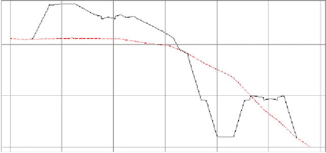
A new profile view shows existing ground in red and proposed ground
in black. As you study the profile, you should be able to identify the
shape of the road in two locations and the shape of the pond in between
(see Figure 18.8).
Road
Pond
Road
Notice the change to
the quick profile. Use
the red polyline and
the quick profile to
study the design of the
project at several dif-
ferent locations.
FiGuRE 18.8
Several prominent design features can be noted in the quick profile.
6.
Click the red polyline to show its grips, and then click one of the grips
and move it to a new location.
◀