Graphics Programs Reference
In-Depth Information
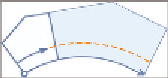
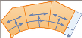
Minimum Frontage
This is the minimum length of the lines or arcs that make
up the side of the lot that is coincident with a road right-of-way. This is also a
common parameter that designers must meet to satisfy zoning requirements.
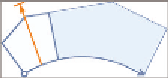
use Minimum Frontage At offset
Some zoning regulations allow the front-
age to be measured at the building setback line rather than at the frontage line
itself. This would enable you to create a larger number of smaller lots, especially
when creating lots along the outside of a curve.
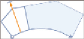
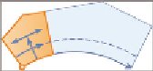
Frontage offset
This parameter is typically used to define the building
setback line.
Minimum Width
This is the minimum width allowed for the resulting parcel.
Minimum Depth
This is the minimum depth allowed for the parcel, measured
perpendicular to the frontage at its midpoint.
use Maximum Depth
This parameter prevents the development of exceedingly
deep lots, potentially enabling the area to be subdivided more efficiently.
Maximum Depth
This is the maximum depth allowed for the parcel, measured
perpendicular to the frontage at its midpoint.
Multiple Solution Preference - use Shortest Frontage
When multiple
solutions are possible, the one that produces the shortest frontage is selected.
Multiple Solution Preference - use Smallest Area
When multiple solu-
tions are possible, the one that produces the smallest area is selected.
In addition to the parcel-sizing parameters, there are parcel-layout parameters
that affect the creation of multiple parcels. The first is Automatic Mode, which
determines whether parcels are created individually or all at once, as follows:
Automatic Mode - on
Multiple parcels are created within the selected area
based on the parameters that have been specified.
Automatic Mode - off
Parcels are created one at a time, and you're
prompted for information for each parcel.