Graphics Programs Reference
In-Depth Information
What Do You See?
As you pan from section view to section view, what story are you being told about
the construction of this road? Which section views do you feel represent areas
that require more time, effort, and money to build as opposed to others? In the
first section views, you can see that the road cross section is much wider on the
left side to account for the turning lane that you built into the corridor. As you
progress further, you see sections that are very close to existing ground eleva-
tions, sections that are some distance above existing ground (a fill condition),
and sections that are some distance below existing ground (a cut condition).
How will the relationship of the road elevation to the existing ground elevation
affect drainage for the homes that will be built along the road? Did you notice
that ditches have been created in places where the road is in a cut condition?
The amount of information and the number of additional questions generated
by these simple pictures of the design are remarkable. The following images
show some of the highlights of the design:
Station 1+50 (0+050) showing the widened left lane
Station 4+50 (0+140) which is in an area that is very close to existing ground
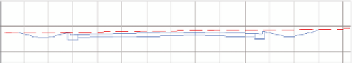
Station 13+50 (0+410) is in an area that is in cut. Note the ditches that are created.
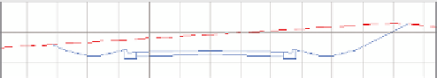
Station 19+50 (0+600) is in an area that is in
�
ll.
Note that no ditches are created in this condition.