Graphics Programs Reference
In-Depth Information
FiGuRE 4.16
Slope analysis of surface
shown in 3D
7.
On the Analysis tab, choose Slope Arrows as the analysis type, and
click the arrow again.
8.
Click OK to return to the drawing. Press Esc to clear the selection of
the surface.
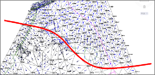
In this view, the darker blues and blacks are the steepest slopes,
and the arrows themselves always point downhill. As you study the
arrows, you should notice a drainage divide that runs west to east
through the farm buildings; it's delineated in red in Figure 4.17. Rain
falling to the north of this area drains to the road, and rain falling
south of it drains to the stream.
FiGuRE 4.17
Slope arrows can be used to identify a drainage divide
(delineated in red) in the project.
9.
Save and close the drawing.
You can view the results of successfully completing this exercise by
opening
Slope Analysis - Complete.dwg
.