Geography Reference
In-Depth Information
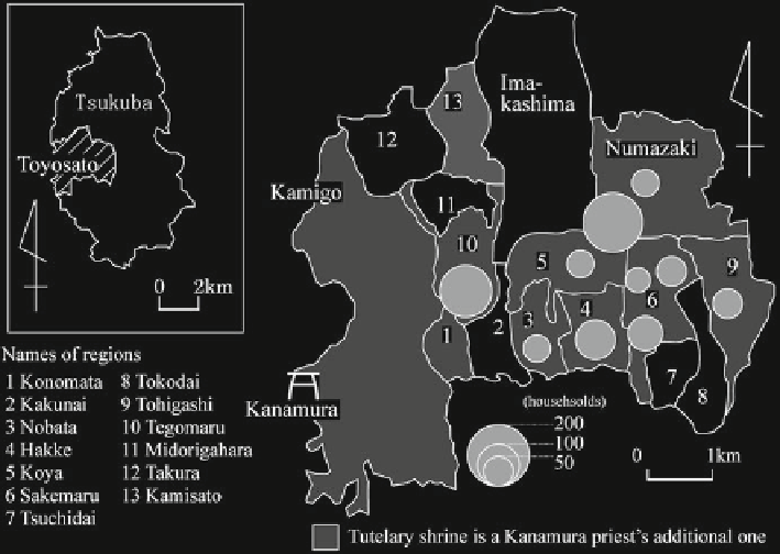
Fig. 3.34
Distribution of communities where a Kanamura priest distributes amulets of a tutelary
shrine, 1995 (The author's fi eld survey in December, 1995)
sea level. There is a long history of fl ooding, so most land was used for paddy agricul-
ture. In the eighteenth to nineteenth century, this area was developed into a collection
and distribution place for early rice crops using the shipping service of Furutone River
(Takeuchi
1980
). Some of the communities located on the natural levee of Furutone
River are old, but most are new or were spun off from main villages by developing
new rice fi elds in the eighteenth to nineteenth centuries. In 1830, there were 1,646
households and some 9,000 people in the area. The National Railroads Corporation
established Yoshikawa station in 1973, and housing development soon accelerated.
The Yoshikawa shopping center opened then and the population increased 1.83 times
from 1965 to 1975, to reach 52,668 in 1995. Yoshikawa became a city in 1995.
3.2.4.1
Spatial Characteristics of the
Kanamura
Faith
in the Yoshikawa Area
(1) The Spatial Characteristics of the
Kanamura
Faith Before 1950
Figure
3.36
shows the distribution of
Kanamura
associations organized in
Yoshikawa area in 1899 and 1949. In 1899, 17 communities organized a
Kanamura
association in communities on a natural levee of Furutone River. In
1949, there were 19 communities, at least 25 communities had a
Kanamura
association before 1950.
Search WWH ::

Custom Search