Geology Reference
In-Depth Information
a
b
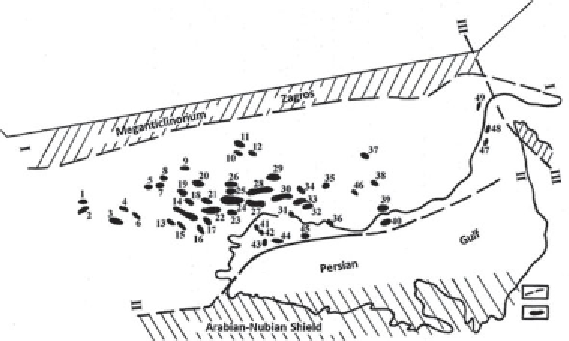
Figure 1.12
Zagros Foredeep. Oil and gas field location map.
a
. Regional faults:
I. Main Zagros overthrust, II. Euphrates-Ramaday, III. Oman;
b
. Oil gas fields. Fields:
1.
Serkan,
2
. Mellekuh,
3
. Dehluran,
4
. Danan,
5
. Kabud,
6
. Chashme Hush,
7
. Lali,
8
. Mesjid-i-Suleiman,
9
. Pare-Sai,
10
. Shurom,
11
. Kuhe-Rij,
12
. Dudrow,
13
. Susengerd,
14
. Ahwaz,
15
. Ab-Teimur,
16
. Mansuri,
17
. Shadegan,
18
. Mullesani,
19
19. Haft-Sefid,
20
. Haft-Kel,
21
. Kupal,
22
. Marun,
23
. Rashmir,
24
. Agha-Djari,
25
. Karanj,
26
. Pariz (Fars),
27
. Rag-E-Sefid,
28
. Paz En Un,
29
. Gachsaran,
30
. Bibi-Hakimeh,
31
. Binak,
32
. Gulhari,
33
. Kilur Karim,
34
. Sulabedar,
35
. Bushghan,
36
. Kuhe-Mand,
37
. Sarvestan,
38
. Agar,
39
. Keng Han,
40
. Keng Han-C,
41
. Hendijan,
42
. Bahregansar,
43
. Houruz,
44
. Darius,
45
. -Xapk,
46
. Kuh Sefid,
47
. Zuru,
48
. Geverzin,
49
. Salah.
are fragments of Euphrates-Ramaday and Euphrates-Persian deep-seated
faults; see Figure 1.12).
The sediment cover includes 8 to 12 km thick Paleozoic, Mesozoic and
Cenozoic rock sections. Average clay content is 24%. The Cambrian and
Devonian intervals are composed of evaporites and clastic deposits, the
Silurian is shales, the Carboniferous-Middle Miocene is predominantly
carbonates and the Upper Miocene-Quaternary is mostly clastic molasses.
Two thick evaporite complexes are identified in the Meso-Cenozoic
section. They include rock salt, gypsum and anhydrite. These complexes
are an Upper Jurassic Hit Formation (Tithonian) up to 900 m thick, and
a Middle Miocene Lower Fars Formation up to 4,500 m thick. The sec-
tion contains numerous depositional hiatuses. Some of these hiatuses are:
between the Upper Jurassic and Lower Cretaceous (the Lower Crertaceous
is missing the entire pre-Aptian section); between the Upper Cretaceous
and Paleogene (the entire Danian is missing); between the Eocene and
Oligocene; Lower and Middle Miocene; Upper Miocene and Pliocene.