Geology Reference
In-Depth Information
a
b
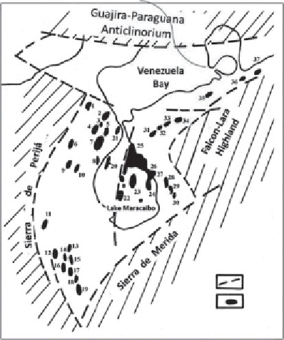
Figure 1.8
Maracaibo basin. Oil and gas field location map.
a
. Regional faults,
b
. Oil and gas fields. Fields:
1
. Amana,
2
. Mara,
3
. Netic,
4
. La Paz,
5
. Concepcion,
6
. Tatumo,
7
. Boscan,
8
. Los Claros,
9
. Macoa,
10
. San Jose,
11
. Rio de Oro,
12
. Tibu,
13
. Los Manueles,
14
. West Tarra,
15
. Tarra,
16
. Sardinata,
17
. Petrolea,
18
. Carbonera,
19
. Rio Sulia,
20
. Urdanetta,
21
. Sibucara,
22
. Lamar,
23
. Centro,
24
. Sauta,
25
. Bolivar,
26
. Lagunillas,
27
. Bochakero,
28
. Mene Grande,
29
. Motatan,
30
. Baruya,
31
. Mene
de Mauroa,
32
. Medio,
33
. Pintado,
34
. Las Palmas,
35
. Tiguaje,
36
. El Mamon,
37
. Cumarebo.
extend along the regional faults are represented by anticlines intensely cut
by normal and reverse faults and overthrusts branching from the major
lengthwise fault forming the anticlinal zone (belt). The throw of the largest
faults reaches and sometimes exceeds 1,000 m and cross-faults reach 200 m.
Commercial oil and gas occurrences are established in all intervals of
the sedimentary complex and at some prospects in the crystalline base-
ment (the La Paz, Tatumo and Mara fields). The productive intervals are
included in the fractured limestones Apon, Copacho (Lower Cretaceous)
and La Luna and in the Mito Juan Formation sandstones in the western
part of the basin, and also in the Miocene complex all over the region. The
main oil and solution gas reserves are associated with the clastic reservoirs
of the Cenozoic formation. Up to 65% of the discovered accumulations
are found at depths shallower than 2,000 m. Several regional oil and gas
accumulation zones are identified within the depression. They include the