Geology Reference
In-Depth Information
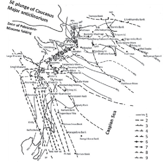
Figure 1.2
South Caspian Depression, western flank. Regional lithotectonic map of
the Middle Pliocene Productive Sequence:
1
. Clay content contours, percent;
2
. Major
faults; pinch-out lines:
3
. Productive Sequence,
4
. Pereryv (lacuna) formation (SP),
5
. Post-Kirmaki clay formation (NKG),
6
. Post-Kirmaki sand formation (NKP),
7
. Kirmaki formation (KS),
8
. Sub-Kirmaki formation (PK),
9
. Kalin formation (KaS).
cross-sections accompanied by consistent negative gravity, electric and
magnetic anomalies. There are in the section tubular subvertical geologic
bodies to a depth of 10
12
km, sometimes deeper (Mamedov, 2001; Ivanov
and Guliyev, 2002). Very common are mud volcanoes and zones of tec-
tonic fracturing.
High micro- and macro-seismicity is common; peculiar, often “inverted”
hydro-geochemical profile and AHFP in the reservoirs and AHPP in the
pore space of impermeable varieties are widespread.
The main commercial oil- and gas-saturation interval in the region is
a thick (up to 5 km) clastic (sandy-clayey) Middle Pliocene series called
Productive Sequence (PT) in Azerbaijan and Iran and Red-Bed Sequence
(KT) in the Western Turkmenistan. It includes almost 95% of all appraised
hydrocarbon reserves in the region. As of today, oil and gas occurrences
−