Geoscience Reference
In-Depth Information
8.5 Case Study: Flood Forecasting in the River Eden Catchment,
Cumbria, England
A flood forecasting system for the River Eden catchment upstream of the town of Carlisle has been
described by Leedal
et al.
(2008). In January 2005, Carlisle suffered a significant flood (with an annual
exceedance probability of less than 0.01), which caused three deaths and damage of the order of £250
million. The inundation of the town was caused by a combination of both pluvial and fluvial flooding
in this event but the flood stage was higher than anything previously observed (Mayes
et al.
, 2006). It
was significantly underpredicted by the Environment Agency forecasting models at the time, primarily
because the inputs to the upland parts of catchment appeared to be significantly underestimated by the
available raingauge data.
The models used by Leedal
et al.
(2008) were similar to the type of data-based mechanistic (DBM)
transfer function models described in Chapter 4, but with some additional features specific to the flood
forecasting situation. Transfer functions were fitted both for rainfall-river flow modelling and for flow
routing in the main channel, the type of cascade of DBM models first used by Lees
et al.
(1994); see
also the case study on flood forecasting for the town of Dumfries in the first edition of this topic and
Box 8.1). In the case of the Eden, a simplifed representation of the catchment was implemented that
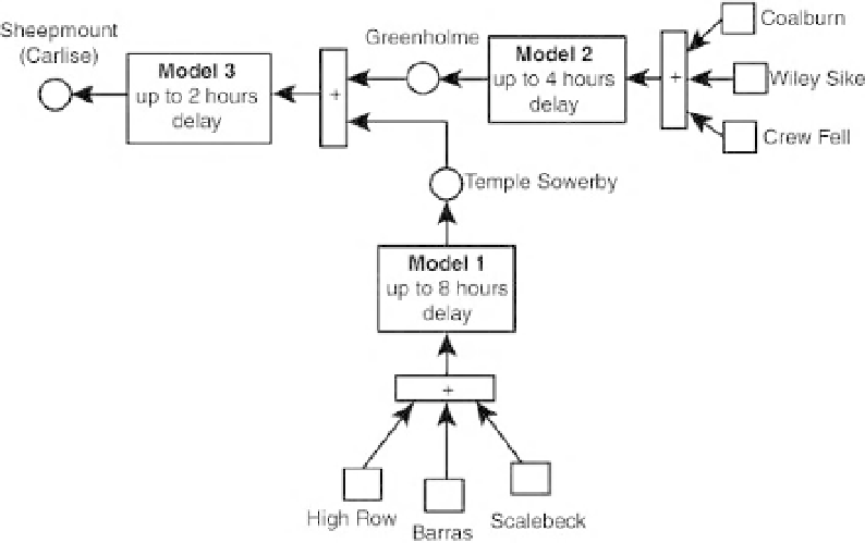
used two headwater basin models and one flow routing model. Thus only six raingauges and three river
gauging sites were used of those available (Figure 8.1).
Recent applications of the DBM approach in the flood forecasting context have made use of rainfall to
water level models in headwater basins and upstream water level to downstream water level models for
flood wave routing. This clearly means that the models being used are not constrained by mass balance,
as would be the case if discharges were used. However, given that in many major flood events, the input
rainfall volumes are not precisely known and the rating curve to convert water levels to discharges at
Figure 8.1
Cascade of flood forecasting system components in the River Eden, Cumbria, UK: The model
assimilates data at each gauging station site (circles) and generates forecasts for Sheepmount with a six-hour
lead time (after Leedal et al., 2008, with kind permission of the CRC Press/Balkema).