Geoscience Reference
In-Depth Information
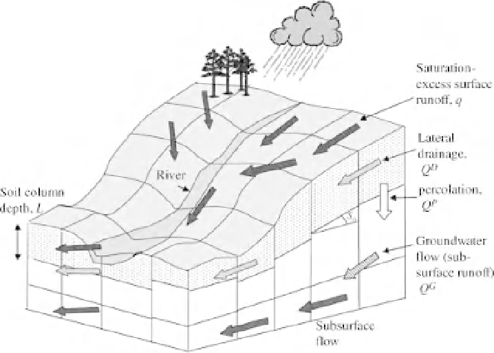
Figure 6.2
Integration of PDM grid elements into the G2G model (after Moore et al., 2006, with kind
permission of IAHS Press).
simple way of distributing the runoff generation representation within the G2G model at the cost of
only two parameters. Soil characteristics are defined using information from the hydrology of soil types
(HOST) classification (Boorman
et al.
, 1995) linked to the SEISMIC soil properties database which
are mapped to 1 km scale (Moore
et al.
, 2006). The model is completed by routing algorithms (hence
the name “grid to grid”) based on simplifications of the kinematic wave theory for surface and channel
flow routing. Subsurface routing between grid elements is achieved by means of a nonlinear function of
groundwater storage.
G2G has also been used for real-time forecasting driven by radar rainfall inputs (Cole and Moore, 2008)
and a model-specific method for data assimilation of observed discharges by modifying the storages in
individual grid elements to correct the overall prediction of discharge. Recent applications have included
the use of the G2G model driven directly from inputs from a 25 km Regional Climate Model using either
historical reanalysis or future climate projections (Bell
et al.
, 2007a, 2007b, 2009). This has included an
assessment of reproducing flood frequency statistics based on continuous simulation (Bell
et al.
2007a)
which is discussed further in Chapter 8.
The G2G model is the first example of a hydrological model for the whole of the UK. It makes use
of calibration where gauging station data are available, but can also provide predictions for ungauged
subcatchments and catchments where data are not available. Any grid element in the country can be
interpreted (or colour coded in a visualisation) for the current state of the flow in either absolute terms
or as a frequency of occurrence. This makes the model a good tool for forecasting purposes and the
G2G model is now being used operationally in the UK (by the joint Environment Agency/Met Office
Flood Forecasting Centre) to make predictions of potential flooding with long lead times. The model is
driven with the Met Office Global and Regional Ensemble Prediction System (MOGREPS) forecasts. The
regional products of MOGREPS, which cover most of the North Atlantic and Europe, are nested within
the global predictions. Each has 24 ensemble members, with perturbations to both the initial conditions
and forecast model, with a grid scale for the Regional Model of 18 km. The G2G model is run on a 1 km