Geography Reference
In-Depth Information
41
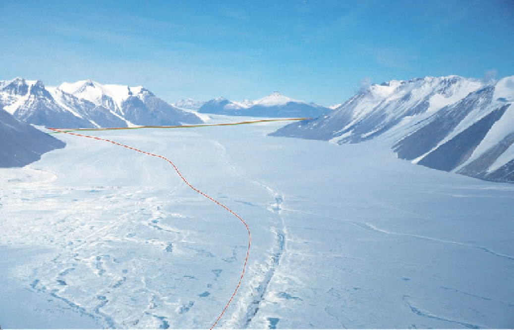
Figure 2.8. Ferrar Glacier, as seen from the mouth of the valley. The Kukri Hills line the right (north)
side of the glacier, Knobhead is the distant peak, and Cathedral Rocks are the prominent buttresses in
the middle ground on the left (south) side of the glacier. The rough ice to the left was what persuaded
Armitage to seek an alternate route onto the middle portion of the glacier. When
Discovery
sailed
past New Harbour in the summer of 1901, Armitage sighted a thin line of white that he thought might
lead to the glacier. The route (in green) that he took down Descent Glacier is, however, in the reen-
trant behind the foremost, dark buttress on the south side of the glacier. The thin lines on the face of
Cathedral Rocks were inaccessible to his party. The closest buttress on Cathedral Rocks is pictured in
Fig. 2.11. Note the narrow icefall in the center of the face. The route that Scott forged up the glacier (in
red) was along its south side, but the smoother north side was what he used on his return.
Beyond the moraine, the glacier itself was a raggedy mess. Weird, contorted pinnacles
and blocks of ice, with relief up to twenty feet, rose from the glacier's surface. Sand and
gravel and boulders were perched, ready to fall, from the tops of pedestals and shoulders,
and were strewn across the pocked marked floor of the ice. The entire glacier seemed to be
in a state of advanced decay. Melting during summer had obviously removed a great deal
of the ice, but this early in the season everything was frozen tight. Armitage did not like
what he saw—a field of grotesque ice traps with no promise of a route through its twisted
maze. After the party's return to Discovery, this image would haunt his preparation for the
western assault.