Geography Reference
In-Depth Information
23
Figure 1.11. (opposite)
Fitzgerald Ice Tongue pours
from the Admiralty Range
directly into Lady Newnes
Bay. In contrast to the open
water that Borchgrevink
sailed in February 1900,
this early-season photo
finds Lady Newnes Bay
frozen solid with ice from
the previous winter.
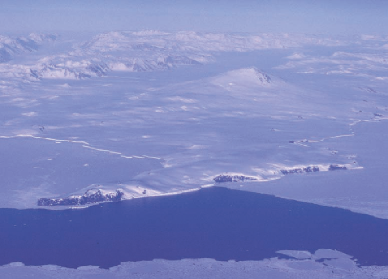
Figure 1.12. Ross's expe-
dition discovered Cape
Washington (the dark ter-
mination of the peninsula
in the lower left), Mount
Melbourne (the volcanic
cone to the right of center),
and Wood Bay (covered by
seasonal ice and extend-
ing out of the image to
the right). Unusually open
water in February 1900
permitted Borchgrevink
to sail in along the coast-
line of Wood Bay for a
distance of twenty miles.
The upper reaches of
Priestley Glacier appear in
the left rear (compare with
Fig. 7.11). Campbell Glacier
silhouettes the left (south)
side of Mount Melbourne,
flowing right to left.
The sight that met our eyes was ineVably desolate. Nothing was visible but the great
ice-cap stretching away for hundreds of miles to the south and west. Unless one has
actually seen it, it is impossible to conceive the stupendous extent of this ice-cap, its
consistency, utter barrenness, and stillness, which sends an indefinable sense of dread
to the heart. There is nothing beautiful to contemplate, no contrasts, absolutely no
diversity, but for all that it is majestic and aVords a profitable theme for meditation.
The ship steamed on down to Franklin Island where a party landed and gave three
cheers for Captain Ross. The coastline to the west remained as poorly charted as when
Ross had visited the region sixty years before. After another landing on a small beach on
the northern edge of Mount Erebus, the ship steamed eastward along the fringe of the
Barrier encountering an inlet at 164° W. The captain moored the ship beside a low spot on
the ice where a three-man party led by Borchgrevink was put ashore. With a dog sledge
they headed south for a distance of about ten miles, thus recording two more firsts, reach-
ing a new “farthest south” and becoming the first to mush dogs on the permanent ice of
Antarctica, albeit a trivial distance.
Although the Southern Cross Expedition added little to what was known of the geog-
raphy of the Transantarctic Mountains, it did accomplish a number of new landfalls and
made geological, biological, and magnetic observations.
Meanwhile, the British National Expedition was slowly taking form. Following the In-
ternational Congress, the Royal Geographical Society petitioned the government to dis-
patch a naval expedition, but the request was denied. In early 1898 Sir Clements Markham
approached the Royal Society, headed by Sir John Murray, for cooperation in a joint