Geography Reference
In-Depth Information
169
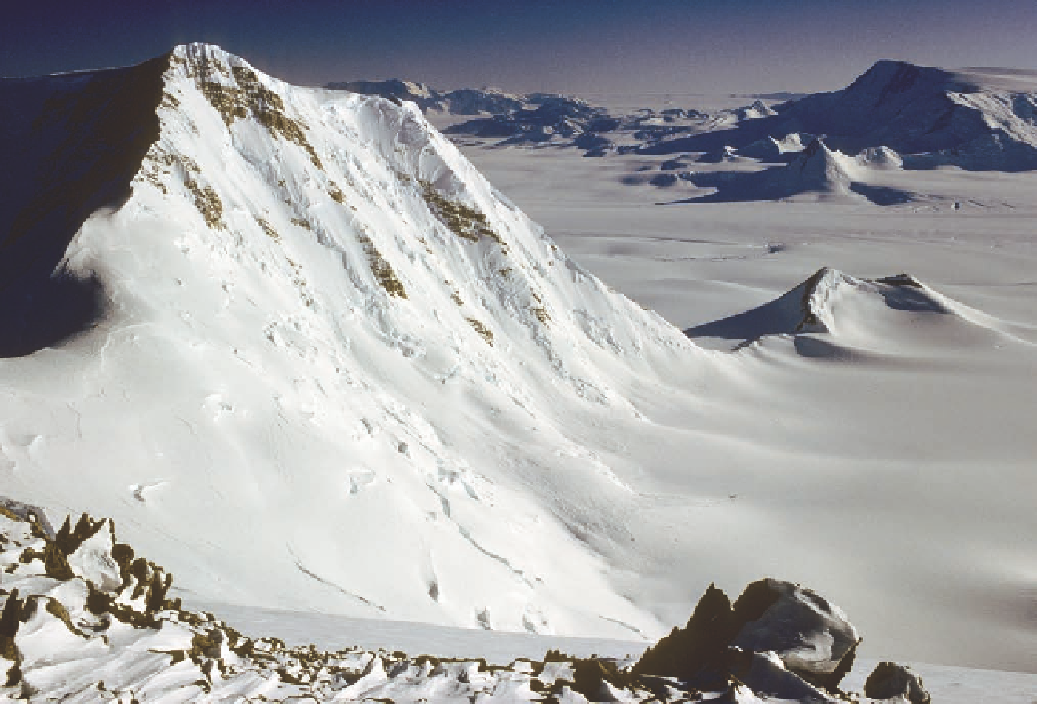
Figure 5.20. Gould's view to the east of Supporting Party Mountain gave the appearance that the
Watson Escarpment gradually dwindled in height for more than 50 miles into the headreaches of
Leverett Glacier. In fact, Leverett Glacier turns abruptly south about 30 miles to the east and cuts
a cleft into the face of the escarpment (see Fig. 5.6). Twenty miles beyond this, what Gould saw as
a dwindling escarpment is in fact a major ridge system that drops to the east-northeast from the
plateau. Beyond this ridge the Transantarctic Mountains extend for another 150 miles. This image,
which reaches nearly to the mountains' end, is taken from the 10,400-foot summit of Mount Ana-
logue, at the crest of the ridge system to the east-northeast of the escarpment. The 6,000-foot
southern face of Mount Doumani dominates the foreground. The dark massif in the middle distance
is Mount Teller. Beyond is Reedy Glacier, the last of the outlet glaciers, which slips from right to left
in front of the dark mountains at the center skyline. Off at the deep end of the horizon, the thin
edge of the Horlick Mountains disappears from sight beneath the ice.
Figure 5.19. (opposite)
Byrd's map of discoveries,
published in 1930. Note the
repositioning of Carmen
Land, which was dropped
from Gould's map a year
later (compare Fig. 5.8).
Reproduced by permis-
sion of the Richard E. Byrd
family.
On December 31, after repacking and giving the dogs a rest, the party set oV across
the Ross Ice Shelf for Little America. Twenty days later the men arrived at their destina-
tion. In the course of their journey, 1,525 miles had passed beneath their runners.
Perhaps more important than geographical discoveries, BAE I demonstrated the
possibilities of airborne exploration into the heart of Antarctica, traversing territory in a