Geography Reference
In-Depth Information
159
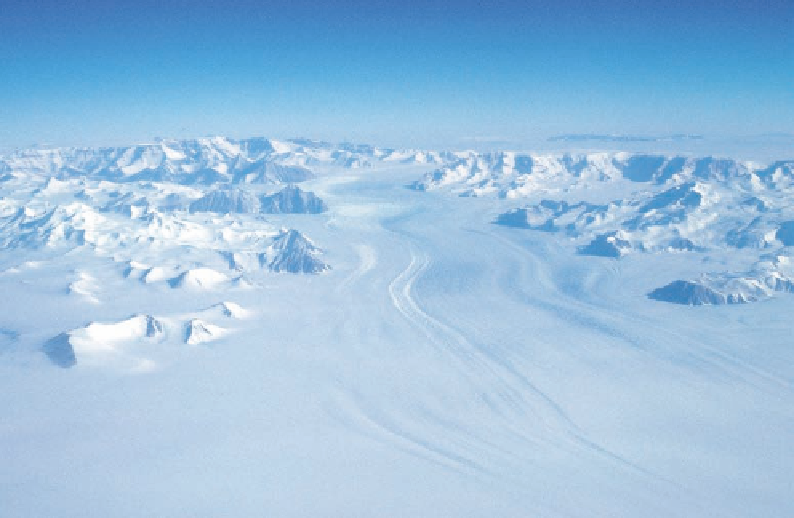
Figure 5.13. Swaths of
crevasses roughen the
surface of Amundsen
Glacier. Snaking into view
from behind Breyer Mesa,
this torrent of ice sweeps
under Nilsen Plateau, then
caroms through staggered
ridgelines to the ice shelf
in the fore. There Gould's
party was passing on the
afternoon of December 17,
1929.
the mountains and glaciers that were opening to the south. To the east of Mount Ruth
Gade was a snowy glacier cutting a straight and narrow swath through the mountains
from the plateau. This was named Bowman Glacier for Isaiah Bowman, director of the
American Geographical Society (see Fig. 5.3).
By midday the party was “looking up the most stupendous glacier” that they had yet
seen, exceeding even the Liv in scale. Gould named this Amundsen Glacier, a ribbon of
lacerated ice flowing down from the ice cap to the west of the bold, flat-topped Nilsen
Plateau, through a middle and foreground (Fig. 5.13). Here the sedimentary layers on the
upper slopes that gave the mountains their blocky character retreated far back from the
mountain front, as the foreground was dominated by jagged, alpine peaks composed of
granite and metamorphic rocks of the basement. Three peaks that rose high above all the
others at the eastern boundary of Amundsen Glacier's catchment were named Mounts
Crockett, Vaughan, and Goodale (see Fig. 5.6).
Later in the afternoon, a vast field of blue ice loomed ahead of the party, so the
men turned abruptly south to the closest outcrop of rock, where they camped with the
hope of gaining a vantage of what lay ahead. These foothills were rounded nubbins that
had been flowed over in the past by ice at a higher stand of the glaciers. Their bedrock
was composed of metamorphic layers interspersed with granitic dikes. A novelty of these
rocks was the presence of green stains indicating a low level of copper mineralization.
Gould named the summit O'Brien Peak, for the surveyor of the party. The view to the
east showed no way to avoid the blue ice and to continue in that direction. Moreover,
the growing doubts about the reality of Carmen Land were finally laid to rest (Fig. 5.14).
Gould states, “We found that the range did not trend southeastward from the vicinity of
Axel Heiberg Glacier as Amundsen thought but rather it is continued in an almost due
easterly direction from it. Furthermore we looked away toward the east and north for